Search This Blog

Monday, February 8, 2016

Russia Launches First GLONASS-M Navigation Satellite in More Than a Year

As reported by Inside GNSSIn its first GLONASS-M launch in more than a year, Russia lifted a satellite into orbit yesterday (3:21 a.m. Moscow time, February 7, 2016) from the Pletsetsk Cosmodrome, after being postponed from December.

GLONASS-M #51 (GLONASS constellation designation #751) will replace a 10-year-old satellite (GC#714) that ceased operations last October in slot 17, orbital plane 3 of the constellation.
The satellite reached orbit aboard a Soyuz-2.1b rocket with a Fregat upper stage. Three and a half hours from the lift off the satellite separated from the upper stage and ground control established communications with it, according to Information Satellite Systems (ISS) – Reshetnev Company, which built the spacecraft.
According to the telemetry data received from GLONASS #51, the satellite is in good health, Reshetnev said in a news release. “With all its mechanical subsystems successfully deployed, the satellite completed Earth and Sun acquisition. The Moscow-based System Control System and ISS-Reshetnev’s Information and Computation Center have already begun satellite’s performance check-out.” 

Eight launch-ready GLONASS-M navigation satellites are currently stored at ISS-Reshetnev Company.

GPS and the World's First "Space War"

As reported by Scientific AmericanTwenty-five years ago U.S.-led Coalition forces launched the world’s first “space war” when they drove Iraqi troops out of Kuwait. Although the actual fighting did not take place in the upper reaches of the atmosphere, satellite-based global positioning systems (GPS) played a critical role in the Coalition’s rapid dismantling of Saddam Hussein’s military during the 1991 Persian Gulf War. Without their orbiting eyes in the sky U.S. troops in particular would have had a much more difficult time navigating, communicating and guiding their weapons across the hundreds of kilometers of inhospitable, windswept desert battlefields in Kuwait and Iraq.


GPS would change warfare and soon became an indispensable asset for adventurers, athletes and commuters as well. The navigation system has become so ubiquitous, in fact, that the Pentagon has come full circle and is investing tens of millions of dollars to help the military overcome its heavy dependence on the technology. GPS’s relatively weak signals are often unreliable and susceptible to interference, also known as “jamming.” This has prompted the Defense Advance Research Projects Agency (DARPA) to begin developing navigational aids that function when satellite access is unavailable.

“Where am I?”

In January 1991, months after Iraq’s
 invasion and occupation of neighboring Kuwait put the international community on alert, the U. S. and more than a dozen other countries launched Operation Desert Storm. The weeks-long air offensive unleashed stealth bombers, cruise missilesand laser-guided “smart” bombs on Iraq’s communications networks, weapons plants and oil refineries. Clearing Hussein’s forces out of Kuwait, however, required ground fighting, a daunting prospect for the Coalition members unaccustomed to desert warfare. “The introduction of GPS was particularly timely for U.S. forces in the Gulf War, primarily to address the age-old question of where am I, and where am I going?” says Col. Anthony Mastalir, vice commander of the 50th Space Wing, U.S. Air Force Space Command based at Schriever Air Force Base in Colorado. Schriever houses the master control station used to determine U.S. GPS satellite orbits and update their navigation instructions. “That information is especially important when you have very few landmarks or reference points as the troops did."

The U.S. military faced several challenges when the ground campaign began on February 24, 1991. For starters, U.S. Army artillery units assigned to fire missiles on enemy defenses and clear the way for infantry troops historically required a day or so to survey a battlefield and set up munitions. This would not be the case in Kuwait as the infantry’s armored tanks, trucks and other vehicles moved swiftly, capable of travelingupward of 50 kilometers per hour. Such speeds would require artillery guns to be quickly set up, fired and moved to the next site. Failure to do that meant the infantry would not get enough artillery support in advance of engaging the Iraqis. Fears that the enemy would resort to chemical weapons against the Coalition’s infantry only accentuated the need for efficient artillery cover. The Pentagon was counting on GPS to help solve this problem.

Another challenge involved a key component of the U.S.’s ground strategy—moving infantry and artillery into even less hospitable areas of the desert in order to outflank and encircle Iraqi forces. GPS would be crucial to helping ground troops “navigate through terrain that the Iraqis weren’t bothering to defend because they didn’t think anyone could find their way through there,” says Marc Drakea retired U.S. Air Force major who served as chief of operational analysis for the 2nd Space Operations Squadron during the Gulf War. The squadron operates Schriever’s master control station as well as the network of worldwide monitoring stations and ground antennas that control and support the U.S.’s GPS satellite constellation.

Mom and dad, please send GPS

The Army’s decision to rely on GPS was a big gamble. A fully operational GPS constellation requires 24 satellites, something the U.S. would not achieve until April 1995. In early 1991 the U.S. Air Force’s Navstar (Navigation System Using Timing and Ranging) constellation included only 16 satellites, and six of those were older research and development units repurposed to help with the war effort. Unlike today’s 24/7 GPS coverage, the satellites in the original Navstar constellation could align long enough to provide about 19 hours each day. Accuracy would be within 16 meters, give or take, better than earlier GPS systems that had a several kilometers margin of error but not quite on par with today’s to-the-centimeter precision.

Signal issues aside, GPS receivers were also in short supply. For starters, there were only 550
 PSN-8 Manpack GPS receivers to go around. Troops fortunate enough to be issued Manpacks mounted these eight-kilogram devices—which cost $45,000 apiece—to their vehicles. A second, more portable option was the 1.8-kilogram AN/PSN-10 Small Lightweight GPS Receiver (SLGR), or “slugger.” The military had about 3,500 of the Trimble Navigation–made SLGR devices available for use in the Gulf War. “You would hear stories about Air Force, Navy and Army personnel having mom and dad send them civilian GPS receivers so they could find their way out there,” says Drake, who currently serves as a space vehicle operations support manager at Schriever. They would fasten the devices to their Humvees or tanks using Velcro, screws or duct tape as they maneuvered through unfamiliar territory. One of the most popular was the $3,000 NAV 1000M Receiver, which Magellan Corp. had been selling to boaters, hikers and other adventurers since the late 1980s.

How GPS works

GPS consists of three components: satellites, receivers and ground control stations. Navstar currently has 31 operational satellites that orbit at about 20,000 kilometers above Earth every 12 hours. The constellation uses six equidistant orbital planes, with four satellites in each plane, Mastalir says.GPS satellite signals carry a time code marked by their atomic clocks, which essentially keep time by measuring the oscillations of atoms. The clocks enable each satellite in the Navstar constellation to continuously broadcast a signal that includes the time and the satellite’s exact position.


GPS receivers—whether they are installed in ships at sea or embedded in wristwatches—calculate their latitude, longitude and altitude by measuring the relative time delay of signals broadcast by at least four different satellites. Ground control, meanwhile, consists of five monitoring stations, three ground antennas and Schriever’s master control station, which communicates with the satellites via the ground antennas.

Navigating victory

Although GPS accuracy and reliability today is a lot better than it was 25 years ago, the coalition’s gamble paid off. During the ground war, which lasted only about 100 hours, GPS receivers helped greatly with land navigation and artillery support, which was part of the massive bombardment that Iraqi soldiers referred to as “
steel rain.” GPS supplemented or even replaced the artillery surveyor’s compass, telescopelike aiming circle, slide rule and other tools of the trade. GPS was also at the heart of new artillery weapons including the Army Tactical Missile System, which debuted during the Gulf War, had a range of about 270 kilometers and used Navstar satellite guidance to home in on its targets.


A NAVSTAR GPS SATELLITE UNDERGOING PRE-LAUNCH TESTING.
COURTESY UNITED STATES AIR FORCE.

Satellite-based navigation proved its mettle in helping the U.S. Army’s VII Corps and XVIII Airborne Corps initiate a flanking maneuver—which different military leaders called the “Hail Mary” or “left hook”—in which troops navigated far to the west of the point in southern Kuwait where the Iraqis expected coalition forces to attack. With only 3,000 GPS devices available for its contingent of 40,000 tanks, Bradley fighting vehicles, howitzer guns and cavalry, the Army units advanced more than 200 kilometers in two days through largely uncharted desert before engaging the Iraqi Republican Guard in the decisive Battle of 73 Eastingon February 26. The battle’s name provides some insight into how much the coalition relied on advanced navigational aids just to reach the enemy—“73 easting” is a north–south line on a map in the middle of the desert as opposed to a town, roadway or some other physical reference point.

GPS jamming

Coalition troops also got a glimpse of GPS’s greatest weakness during the Gulf War. Iraqi forces installed jammers, for example, on top of landmarks such as Saddam Hussein’s palaces to prevent them from being hit, Mastalir says. This helped the military realize early on that it would have to further develop its laser-guided munitions and other weapons that acquire targets when GPS is unavailable, he adds. Jamming disrupts a receiver’s ability to pick up data from the satellites by adding more noise to the signal transmission. Tinkering with the signal-to-noise ratio is not difficult, given how weak GPS signals generally are by the time they reach Earth. Such signals have been compared with the amount of light given off by a
 25-watt bulb, as seen from about 20,000 kilometers away.

Jamming can, to some degree, be countered by increasing signal strength and using antennas that can better discriminate between signal and noise. At the same time, however, the Pentagon recognizes the danger of relying too heavily on satellite-based GPS. DARPA, which helped miniaturize GPS receivers in the 1980s and developed ways to add GPS guidance to munitions, is now investing in new types of inertial and self-calibrating sensors that could continue to accurately track a receiver’s position when satellite service is not an option. This includes the $50-million Atomic Clocks with Enhanced Stability (ACES) program to develop portable, battery-powered atomic clocks the size of cell phones. The goal is for the next generation of clocks to be 1,000 times more stable than current models and to accurately maintain time and navigation information in devices even when cut off from satellite communications.

If DARPA’s vision comes to fruition, military units could someday be equipped with both
atomic clocks and GPS receivers to help them find their way through hostile territory.

Friday, February 5, 2016

US Air Force Launches GPS Satellite to Complete Navigation Constellation

As reported by Space.com: The final addition to a group of global positioning satellites successfully launched into orbit this morning.

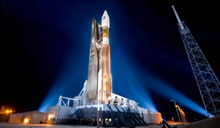
The GPS IIF-12 satellite took off today (Feb. 5) aboard an Atlas V 401 rocket from Complex 41 at Cape Canaveral Air Force Station in Florida at 8:38 a.m. EST (1338 GMT). The satellite was built by Boeing, and is operated by the U.S. Air Force. It is the 12th and final block IIF global positioning system satellite to launch.

"This is a significant milestone for GPS, the 50th GPS satellite to be delivered on-orbit," said Lt. Gen. Samuel Greaves, Space and Missile Systems Center commander and Air Force program officer for space, in a statement from Patrick Air Force Base in Cape Canaveral. "The GPS IIF satellite performance has been exceptional and is expected to be operational for years to come."

The Atlas V rocket is built by United Launch Alliance (ULA), a joint venture between Boeing and Lockheed Martin. As with previous IIF satellite launches, the rocket was in a 401 configuration, which consists of a 4.2-meter (13.7 feet) payload fairing and two booster stages.

GPS satellites fly at an altitude of about 12,550 miles (20,200 km), and provide global positioning, navigation and timing services to both civilians and military personnel.

The IIF-12 launch date was initially delayed when ULA officials were alerted to a possible problem with electrical connectors in the Atlas V booster. In a media briefing Jan. 29, Walter Lauderdale, the GPS IIF-12 mission director, said the problem was fully investigated and solved, but delayed the launch by "a couple of days."

"We took the time to inspect all the subject connectors and verified the integrity of those connectors," Lauderdale said. "Frankly, a day or two delay cannot possibly compare to the loss of a vital national asset. That is the nature of a sharp focus on mission success."

Built by Boeing, the $131 million satellite will join a constellation of 30 other operational GPS satellites, the first of which was launched in 1990. The "Block II" family of satellites have consisted of the IIA series, followed by the IIR series, and the IIF series. The first IIF satellite was launched in 2010, and the GPS-11 satellite was launched on Oct. 31, 2015. The IIF-12 satellite is the last in the IIF series, and Boeing is already working on an IIIF series of satellites to join the GPS constellation.

During a live broadcast of the launch, Dan Hart, vice president of government satellite systems for Boeing, spoke about the improvements of the IIF series from previous series used in this GPS constellation. According to Hart, the IIF satellites have improved clocks; a jam-resistant military signal; and a new, dedicated civilian signal that is particularly useful for commercial aviation and search-and-rescue operations.

Elon Musk 'Tempted' to Build Electric Vertical Take-Off and Landing Jet

As reported by IBTimes: Elon Musk says he is close to working out how to build an electric jet which would take off and land vertically. The Tesla boss revealed his plans during a question-and-answer session at the Hyperloop Pod competition in Texas.

Such a plane may sound impossible, but Musk has a strong track record for turning concepts into reality. He has brought electric cars into the mainstream with Tesla, is experimenting with reusable space rockets at SpaceX, and is now involved with Hyperloop, his plan for a 700mph train.

Speaking at the Hyperloop event, Musk answered the question of what his next "great idea" will be, by saying: "I've been thinking about the vertical-take off and landing electric jet a bit more. I think I have something that might close. I'm quite tempted to do something about it." Musk's comments were initially met with quiet laughter, then cheers and applause as the audience realised he was being serious.

Naturally, the next question fired at Musk was "How do you convince people that your ideas aren't crazy?", to which he answered: "In starting SpaceX, they definitely thought I was crazy. One of my best friends compiled a long video of rockets crashing and made me watch the whole thing. Other friends involved in a rocket startup said it was a terrible idea, and I thought we had a really tiny chance of succeeding anyway, like 10%... and it was very close [to failure] but I think, ultimately, seeing is believing... that's what convinces people."


History repeating
This is not the first time Musk has talked about building an electric jet. During an interview with Marketplace in October 2015, Musk said: "I do like the idea of an electric aircraft company. I do think one could do a pretty cool supersonic, vertical-take off and landing electric jet. That would be really fun."

When asked if he was just making things up, Musk said: "No, I have a design in mind for that, but I have too many things on my plate to do, and then of course there is the Hyperloop."

In 2014, Musk also mentioned his electric plane ideas during an interview with the Massachusetts Institute of Technology (MIT), when he said he was "toying" with the concept, adding: "I would love to do it, but I think my mind would explode."

Musk's comments come in the same week which saw budget airline EasyJet announce it is looking at producing hybrid electric airliners. The plans describe a kinetic energy recovery system (Kers) similar to that used by Formula One cars, where energy created by braking when landing would be stored in a battery and used to run and even taxi the plane without using its jet engines.


Thursday, February 4, 2016

Obama Proposes $10 per Barrel Oil Tax to Fund Clean Transportation

As reported by Engadget: President Obama has proposed a $10 per-barrel tax on oil to fund cleaner mass transit and cleaner vehicle research. The plan, laid out in a fact sheet, is a "smart, strategic integrated investments to help reduce carbon pollution, strengthen economy" according to the White House.

The fact sheet notes that 30 percent of the nation's green house gas emissions come from public transportation. The proposed tax is expected to increase investment in a clean transportation by 50 percent.

That includes $20 billion per year raised by the new tax being used to fund public transportation to reduce traffic and pollution. While approximately $10 billion per year will be used to fund cities and states that come up with solutions for cutting emissions. About $2 billion will be allocated for clean and autonomous vehicle research.


As expected, the oil industry is not amused. American Petroleum Institute CEO Jack Gerard issued the following statement: "The White House thinks Americans are not paying enough for gasoline, so they have proposed a new tax that could raise the cost of gasoline by 25 cents a gallon, harm consumers that are enjoying low energy prices, destroy American jobs and reverse America's emergence as a global energy leader." He continued,"On his way out of office, President Obama has now proposed making the United States less competitive."

The proposal will have a tough time in the Republican controlled House and Senate. Actually, there's a good chance it's going to die rather quickly once it leaves the White House.

Wednesday, February 3, 2016

Scientists in Germany Take Another Major Step Towards Nuclear Fusion

As reported by GizmodoPhysicists in Germany have used an experimental nuclear fusion device to produce hydrogen plasma in a process similar to what happens on the Sun. The test marks an important milestone on the road towards this super-futuristic source of cheap and clean nuclear energy. 

Earlier today in an event attended by German Chancellor Angela Merkel (herself a PhD physicist), researchers from the Max Planck Institute in Greifswald turned on the Wendelstein 7-X stellarator, an experimental nuclear fusion reactor. (Actually, the researchers let Merkel do the honors.) This €400 million ($435 million) stellarator is being used by physicists to test the technical viability of a future fusion reactor.
Unlike nuclear fission, in which the nucleus of an atom is split into smaller parts, nuclear fusion creates a single heavy nucleus from two lighter nuclei. The resulting change in mass produces a massive amount of energy that physicists believe can be harnessed into a viable source of clean energy.
It’ll likely be decades (if not longer) before true nuclear fusion energy is available, but advocates of the technology say it could replace fossil fuels and conventional nuclear fission reactors. Unlike conventional fission reactors, which produce large amounts of radioactive waste, the by-products from nuclear fusion are deemed safe. 
Scientists in Germany Take a Major Step Towards Nuclear Fusion
Via Max-Planck-Institut für Plasmaphysik, Tino Schulz - Public Relations Department, Max-Planck-Institut.
Back in December, the same team of researchers fired up the donut-shaped device for the first time, heating a tiny amount of helium. During today’s experiment, a 2-megawatt pulse of microwave was used to heat the hydrogen gas and convert it into an extremely low density hydrogen plasma. “With a temperature of 80 million degrees and a lifetime of a quarter of a second, the device’s first hydrogen plasma has completely lived up to our expectations,” said physicist Hans-Stephan Bosch in a press statement.
W7-X isn’t expected to produce any energy, but it will be used to test many of the extreme conditions that future devices will be subjected to in order to generate power. Temperatures within the device could conceivably reach 180 million degrees F (100 million degrees C). 
As noted by John Jelonnek, a physicist at Germany’s Karlsruhe Institute of Technology in a Guardian article, “It’s a very clean source of power, the cleanest you could possibly wish for. We’re not doing this for us but for our children and grandchildren.”

China Launches New MEO BeiDou Navigation Satellite

As reported by Inside GNSSChina successfully completed its first BeiDou launch of the year, lifting a new-generation satellite into orbit yesterday (February 1, 2016) and adding to its 17 operational spacecraft in the nation’s GNSS (GPS-like) constellation.

The fifth of the new series, the middle-Earth-orbiting (MEO) satellite will join its four predecessors in testing inter-satellite crosslinks and a new navigation payload that will set the framework and technical standards for global coverage, according to the Xinhua state news agency.
Designated BDS M3-S, this is the first of two BeiDou satellites scheduled for launch in 2016, according to China Aerospace Science and Technology Corporation. The spacecraft contains a technology demonstator —identified as a “chip” by program officials — that will, if proved successful, help in the design of smaller, better integrated, more reliable satellites, BeiDou deputy commander-in-chief Li Guotong said. It also contains a particle detector to assess radiation conditions in the BeiDou constellation's environment.
According to Libin Xiang, commander-in-chief of the BeiDou Navigation Satellite System (BDS) project, the latest satellite is crucial to implementing a transition from the regional system declared operational in December 2011 and a full-fledged system expected to be completed by 2020.
"Our new intersatellite crosslink system, featuring strong disturbance resistance and high-level privacy, is the core technology to compete with other countries' navigation networks. The new satellite will fully verify our technology," said Baojun Lin, the satellite's chief designer.
Lin said the satellite will operate without the help of ground control and broadcast continually, key requirements for navigation services.
According to Xinhua, China plans to expand the Beidou services to most of the countries covered in the Silk Road Economic Belt (also knowns as the “Belt and Road”) initiative by 2018, a swatch of countries stretching through Central Asia, West Asia, the Middle East, and Europe.
The Beidou Phase III system of which BDS M3-S will be a part will migrate its civil B1 signal from 1561.098 MHz to a frequency centered at 1575.42 MHz – the same as the GPS L1 and Galileo E1 civil signals.  The former quadrature phase shift keying (QPSK) modulation will be a time-multiplexed binary offset carrier (TMBOC) modulation similar to the new civil GPS L1C and Galileo's Open Service signal.Meanwhile, a United Launch Alliance Atlas V 401 will place the final GPS follow-on block satellite (IIF-12) into orbit for the U.S. Air Force on Friday (February 5, 2016) from Cape Canaveral Air Force Station, Florida. A 19-minute launch window opens at 8:38 a.m. EST. On Sunday (February 7, 2016), Russia is scheduled to launch another GLONASS-M satellite from the Plesetsk Cosmodrome north of Moscow.

Monday, February 1, 2016

The Oil Crash is Kicking Off One of the Largest Wealth Transfers in Human History: $3 Trillion per Year

As reported by Yahoo FinanceEconomists are still hotly debating whether the oil crash has been a net positive for advanced economies.

Optimists argue that cheap oil is a good thing for consumers and commodity-sensitive businesses, while pessimists point to the hit to energy-related investment and possible spillover into the financial system.
A new note from Francisco Blanch at Bank of America Merrill Lynch, however, puts the oil move into a much bigger perspective, arguing that a sustained price plunge "will push back $3 trillion a year from oil producers to global consumers, setting the stage for one of the largest transfers of wealth in human history."
Blanch and his team already see evidence that the fall in the price of crude is having a positive impact on demand, and say that it could accelerate even further if prices don't pick up. 
Says Blanch: "Alternatively in a lower oil price scenario, e.g. if prices were to average just $40 over the next five years which is close to the current forward curve, demand would grow by 1.5 million barrels per day, which is 0.3 above our base case. Finally, at $20 oil demand would grow by an explosive by 1.7 per year on average, 0.5 above the base case, on our estimates."
Meanwhile, in emerging markets, where much of the story of late has been about disappointing economic growth, Blanch still sees huge upside potential in terms of automobile penetration and consumption.
Take China for example, where the strategist sees the oil plunge helping to fuel a boom in SUV sales: "Moreover, the low oil price is encouraging Chinese consumers to buy increasingly larger cars. Sales of SUVs, the heaviest passenger vehicles category, are up 60 percent year-on-year in the last three months, while overall passenger vehicle sales are growing robustly at 22 percent."
And it's not just emerging markets where the impact of cheaper gasoline is being seen. 
After years of stagnation, vehicle miles traveled in the U.S. clearly ticked higher in 2015.
Combine these trends with the decline in, say, Saudi Arabia's foreign exchange reserves, or the stock price of any oil company, and you can see the dramatic wealth shifts now taking place in the world. 

MIT Hyperloop Team Rockets Past Competition

As reported by the Boston HeraldIt may seem like so much pie in the sky right now, but a globally embraced dream of creating a levitating, 700-mile-per-hour public transit system is already coming true for enterprising engineers at the Massachusetts Institute of Technology, who learned Saturday that their design of a futuristic bullet train bested 100 others submitted from around the world for the SpaceX Hyperloop.

“Wow! We are beyond excited to announce we just won 1st place in the SpaceX Hyperloop competition!!!!!!!!” the MIT Hyperloop team posted on Facebook from the weekend competition at Texas A&M University, along with a video showing them erupting in screams, whistles and applause as their winning entry was announced.

MIT’s team of more than two dozen graduate and undergraduate students will receive $50,000 from Hyperloop Technologies Inc. to build their creation.

Powered by renewable energy, Hyperloop aims to rocket floating passenger pods through elevated tubes at nearly the speed of sound. California-based aerospace company SpaceX, which sponsored the design competition, is planning to start testing human-scale pods on a specially designed track as early as this summer.

Elon Musk, SpaceX’s billionaire brainiac, told the awards ceremony his inspiration for Hyperloop comes from being stuck in Los Angeles traffic and being an hour late for a speech.

“I’m starting to think this is really going to happen,” Musk said. “It’s clear that the public and the world wants something new, and it’s clear that you guys are going to bring it to them.”

Friday, January 29, 2016

Army Demonstrates Autonomous Vehicle Capabilities at Detroit Auto Show

As reported by Popular Mechanics: The military is continuing to experiment with autonomous vehicle technologies. Earlier this month, the U.S. Army successfully deployed a fully-autonomous ground vehicle by having it flown in by a fully-autonomous helicopter. Now the Army has revealed that autonomous driving technology can be used in a number of their trucks and military vehicles.

At the Detroit Auto Show, the U.S. Army Tank Automotive Research, Development, and Engineering Center (TARDEC) showed off one of its autonomous vehicles. In addition to cutting down on required personnel by having a convoy of autonomous vehicles follow one human driver, driverless vehicles could also navigate areas with a high number of IEDs or other hazards without risking human life. A new video from Stars and Stripes takes a look at the new driverless Army trucks. 
Just like Google's driverless cars, the autonomous military vehicles use a LIDAR system to create a three-dimensional world map and navigate around obstacles. The Army's large autonomous trucks are still being developed—they're a little harder to fine tune than the little pods that Google has out on the roads—but finding new ways to perform wartime operations while keeping soldiers out of harm's way is one of the Army's top priorities.

Droneboarding: The Sport We Should Have Seen Coming

As reported by The VergeOkay, there's a lot going on here so let's break things down. Is it impractical to use quadcopters to tow a toddler on a snowboard? Yes, very. Did the battery on the drone in this video last long? Probably not. Did the kid go very fast? He's barely moving. Is this a great idea? Of course, of course, of course.
Using a consumer grade drone to tow people on snow (or on water?) makes about as much sense as strapping a giant fan to someone's back while they're paragliding — but people do that and it looks like great fun. And while drones may be pretty weak with batteries that only last tens of minutes, they are at least getting stronger, and we can definitely imagine a team of drones pulling a fully-grown human. Maybe they could do it on a sled? Like huskies? Hunting down rogue robots through the future-frozen wastelands of middle America after the coming Ice Age / AI revolt??
Okay, that's too far, but this is still pretty alright.