As reported by Popular Mechanics: On December 15, the United States Air Force successfully flew an AI copilot on a U-2 spy plane in California, marking the first time AI has controlled a U.S. military system. In this Popular Mechanics exclusive, Dr. Will Roper, the Assistant Secretary of the Air Force for Acquisition, Technology and Logistics, reveals how he and his team made history.
For Star Wars fans, an X-Wing fighter isn’t complete without R2-D2. Whether you need to fire up converters, increase power, or fix a broken stabilizer, that trusty droid, full of lively beeps and squeaks, is the ultimate copilot.
Teaming artificial intelligence (AI) with pilots is no longer just a matter for science fiction or blockbuster movies. On Tuesday, December 15, the Air Force successfully flew an AI copilot on a U-2 spy plane in California: the first time AI has controlled a U.S. military system.
Completing over a million training runs prior, the flight was a small step for the computerized copilot, but it’s a giant leap for “computerkind” in future military operations.
The U.S. military has historically struggled developing digital capabilities. It’s hard to believe difficult-to-code computers and hard-to-access data—much less AI—held back the world’s most lethal hardware not so long ago in an Air Force not far, far away.
But starting three years ago, the Air Force took its own giant leap toward the digital age. Finally cracking the code on military software, we built the Pentagon’s first commercially-inspired development teams, coding clouds, and even a combat internet that downed a cruise missile at blistering machine speeds. But our recent AI demo is one for military record books and science fiction fans alike.
With call sign ARTUµ, we trained µZero—a world-leading computer program that dominates chess, Go, and even video games without prior knowledge of their rules—to operate a U-2 spy plane. Though lacking those lively beeps and squeaks, ARTUµ surpassed its motion picture namesake in one distinctive feature: it was the mission commander, the final decision authority on the human-machine team. And given the high stakes of global AI, surpassing science fiction must become our military norm.
Our demo flew a reconnaissance mission during a simulated missile strike at Beale Air Force Base on Tuesday. ARTUµ searched for enemy launchers while our pilot searched for threatening aircraft, both sharing the U-2’s radar. With no pilot override, ARTUµ made final calls on devoting the radar to missile hunting versus self-protection. Luke Skywalker certainly never took such orders from his X-Wing sidekick!
The fact ARTUµ was in command was less about any particular mission than how completely our military must embrace AI to maintain the battlefield decision advantage. Unlike Han Solo’s “never-tell-me-the-odds” snub of C-3PO’s asteroid field survival rate (approximately 3,720 to 1), our warfighters need to know the odds in dizzyingly-complex combat scenarios. Teaming with trusted AI across all facets of conflict—even occasionally putting it in charge—could tip those odds in our favor.
But to trust AI, software design is key. Like a breaker box for code, the U-2 gave ARTUµ complete radar control while “switching off” access to other subsystems. Had the scenario been navigating an asteroid field—or more likely field of enemy radars—those “on-off” switches could adjust. The design allows operators to choose what AI won’t do to accept the operational risk of what it will. Creating this software breaker box—instead of Pandora’s—has been an Air Force journey of more than a few parsecs.
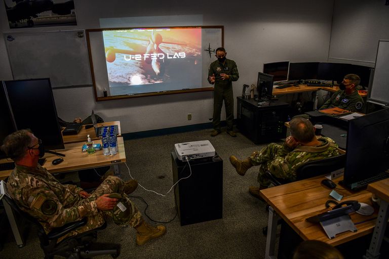
Dr. Jeannine Abira, U-2 Federal Labratory Director of Advanced Mathamatics and Algorithim Development (left) and Dr. Jesse Angle, U-2 Federal Laboratory Technical Director (right), work on a computer Sep. 21, 2020 at Beale Air Force Base, California. The U-2 Federal Laboratory is a 15 U.S.C. compliant organization that promotes “edge development” a concept to develop new software integration on operational systems.
A1C LUIS A.RUIZ-VAZQUEZ
U.S. Air Force Gen. Mark Kelly, right, commander of Air Combat Command, and U.S. Air Force Command Chief Master Sgt. David Wade, Air Combat Command, receive a brief from U-2 Federal Laboratory staff about the organization’s stand-up and recent projects, Dec. 4, 2020, at Beale Air Force Base, California.
U.S. AIR FORCE PHOTO BY STAFF SGT. COLVILLE MCFEE
The journey began early in 2018, when I approved a hoodie-wearing Air Force team (fittingly named Kessel Run for a Star Wars smuggling route) to “smuggle” commercial DevSecOps software practices into our Air Operations Center. By merging development, security, and operations using modern information technology, DevSecOps produced higher-quality code faster and more continuously. Sounds perfect for a digitally-challenged Pentagon, right?
You’d think. Kessel Run bent all the rules and definitely “shot first” at the Pentagon’s fixation on five-year development plans with crippling baselines. As Han Solo advocated, keeping momentum sometimes required a good blaster at our side. Thankfully, Kessel Run’s results were game-changing, outpacing previous programs and inspiring a generation of Air Force and Space Force DevSecOps teams, including our U-2 FedLab.
"GIVEN THE HIGH STAKES OF GLOBAL AI, SURPASSING SCIENCE FICTION MUST BECOME OUR MILITARY NORM."
But coding effectively is only one element of trusted AI design. A year later, I directed a Service-wide adoption of coding clouds using landmark technologies containerization and Kubernetes. Containers virtualize and isolate everything code needs to run for Kubernetes then to orchestrate, selectively powering disparate software like a dynamic-but-secure breaker box.
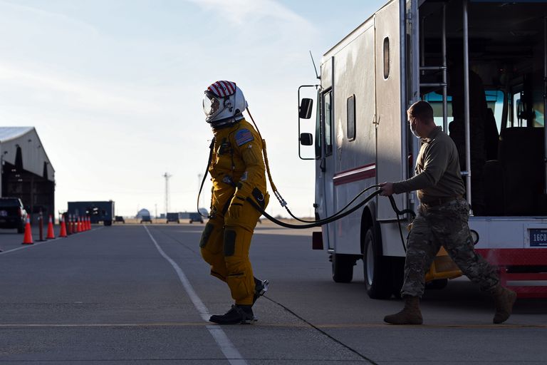
U.S. Air Force Maj. “Vudu”, U-2 Dragon Lady pilot for the 9th Reconnaissance Wing, enters the cockpit while a 9th Physiological Support Airman assists him at Beale Air Force, California, Dec. 15, 2020.
Running ARTUµ containers in our FedLab cloud also proved they would run identically on the U-2—no lengthy safety or interference checks required! This is how we get evolving software—especially AI—out of our clouds and safely onto planes flying through them.
Yet this trusted design didn’t create ARTUµ’s copilot abilities. You have to train for that. Like a digital Yoda, our small-but-mighty U-2 FedLab trained µZero’s gaming algorithms to operate a radar—reconstructing them to learn the good side of reconnaissance (enemies found) from the dark side (U-2s lost)—all while interacting with a pilot. Running over a million training simulations at their “digital Dagobah,” they had ARTUµ mission-ready in just over a month.
So my recent U-2 AI pathfinder—and military AI more generally—was really a three-year journey to becoming a software-savvy Air Force. But why not skip computerized copilots and wingmen and create a purely autonomous Force? After all, a computer won DARPA’s recent dogfight, and we’re already developing autonomous mini-fighters in our Skyborg program.
That autonomous future will happen eventually. But today’s AI can be easily fooled by adversary tactics, precisely what future warfare will throw at it.
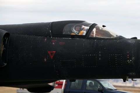
U.S. Air Force Maj. “Vudu”, U-2 Dragon Lady pilot for the 9th Reconnaissance Wing, prepares to taxi after returning from a training sortie at Beale Air Force, California, Dec. 15, 2020.
A1C LUIS A.RUIZ-VAZQUEZ
Like board or video games, human pilots could only try outperforming DARPA’s AI while obeying the rules of the dogfighting simulation, rules the AI had algorithmically learned and mastered. The loss is a wakeup call for new digital trickery to outfox machine learning principles themselves. Even R2-D2 confused computer terminals with harmful power sockets!
As we complete our first generation of AI, we must also work on algorithmic stealth and countermeasures to defeat it. Though likely as invisible to human pilots as radar beams and jammer strobes, they’ll need similar instincts for them—as well as how to fly with and against first-generation AI—as we invent the next. Algorithmic warfare has begun.
Now if only we could master those hyperdrives, too.
It's a lot more than just driving directions. GPS, managed by the US Space Force, is embedded throughout the high-tech world we live in.
On Nov. 5, a SpaceX rocket roared into the heavens from Cape Canaveral, Florida, carrying a boxy, 5,000-pound, antenna-studded satellite toward its destination 12,500 miles away, up in what's known as medium Earth orbit. From that distant vantage point, it'll soon beam signals that will help you find your way to a friend's new house out in the suburbs or a vacation destination six hours down the coast.
If you stop at an ATM along the way to grab some cash, those signals will also help the bank know your withdrawal happened after your direct deposit paycheck refreshed your finances. They'll be a factor, too, in whether your cellphone call to your friend, or the rental agent, goes through without garbling or fading.
Those signals will be coming from a GPS III satellite, the newest member of a constellation of satellites that have become a constant and intimate presence in our daily lives. With GPS III, we're getting not just new boxes in the sky, but a series of upgrades that'll help make the system better for all of us here on Earth. And we'll need it.
The Global Positioning System has become vital to nearly all sectors of the country's critical infrastructure, with much of its work happening behind the scenes, and likely to a much greater extent than you realize. GPS tells us where we are and helps us get where we're going, but a core aspect of the technology is when -- the timing of, well, more or less a zillion things. It plays a critical role in financial transactions and stock trades, forecasting the weather, monitoring earthquakes and keeping the power grid humming.
"It's so much more than just driving directions," says Tonya Ladwig, acting vice president of space navigation systems at Lockheed Martin, which built that satellite.
According to a study last year commissioned by the National Institute of Standards and Technology, GPS has about $1 billion a day in economic impact in the US. Its reach is, simply, mind-blowing.
"Gauging the overall value of GPS is nearly impossible," writes Greg Milner in Pinpoint, a 2016 book about how the space-based system came to be and the effect it's having on the world. "It has become difficult to untangle the worth of GPS from the worth of everything."
That's a lot to put on the shoulders of not much more than a couple dozen satellites and what turns out to be a wisp of signal by the time it reaches your phone or an airplane coming in for a safe landing. Which is why experts and lawmakers have long fretted over GPS' susceptibility to jamming and spoofing and the possibility that this invaluable resource could become a single point of massive failure.
GPS is the premier service among just a handful of global navigation satellite systems, or GNSS, which include the European Union's Galileo, Russia's Glonass and China's BeiDou. It's in the midst of a long-running modernization intended to deliver better signals to folks on the ground and to make the satellites more robust in space. That's good news not just for Uber drivers, pilots, bankers, geologists, farmers doing precision agriculture, and users of drones and self-driving cars but also for the sector that got the whole GPS ball rolling in the first place: the US military.
And the military isn't just a heavy-duty GPS user. It also runs the service, for all of us around the world.
How GPS works
What makes GPS an always-on resource -- every bit as much a reliable utility as the electricity and water in your house -- is the coverage the satellites provide.
There are 31 satellites in the GPS constellation, and 24 are considered the minimum for the core constellation to work as it's supposed to. Those two dozen are spread out in six orbital planes, so you should always be within view of at least four at any given moment. The remaining seven are essentially spares, to be rotated in as necessary. Though they're continuously beaming signals down to Earth that you'll pick up in your phone, fitness tracker or boating sat-nav device, they don't know where you are. They just broadcast, like a radio station in space.
A GPS III satellite stands tall at Lockheed Martin's Littleton, Colorado, facility, in May 2018, a year and a half before its launch into orbit. The striped elements on top are antennas, which will be pointed earthward when the satellite is on orbit.
Lockheed Martin
"The GPS satellites are actually just highly precise atomic clocks, hooked to a radio transmitting a time signal," says Dana Goward, president of the Resilient Navigation and Timing Foundation, a Washington, DC-based nonprofit.
On the ground, your GPS receiver -- which is what your mobile phone is, thanks to a GPS chip -- picks up the signals from four or more satellites. By measuring slight differences in the signals' time of arrival, all the way down to nanoseconds, it can calculate where you are and whether you're in motion.
"[Location] is a byproduct of how the system works," says Scott Burgett, director of GNSS and software engineering at Garmin, which makes devices including fitness trackers and smartwatches. "All the satellites transmit signals, and they're synchronized pretty accurately, but in order to actually get your position information, you have to solve for time."
The timing data gets translated into highly precise three-dimensional location information -- latitude, longitude and altitude -- as well as speed and direction. That's where Google Maps, Apple Maps and other geographic information systems come into play. It's how we get to the part where you have a street address and you say, "I'll put that in my GPS," and Waze lets you know to take Exit 27, go 3.5 miles and turn left into the parking lot of the beer and burger joint you've heard good things about.
Or it just gets used as a time stamp, pure and simple. Think financial transactions, for instance.
"The timing aspect of this is probably more widely used than the where-are-you aspect," says Goward.
Space Force reporting for duty
The US Space Force operates and maintains the GPS constellation. Each satellite -- picture a PODS storage container, metallic rather than white, with solar arrays sticking out like a pair of wings -- makes two transits around the planet every day.
Even as precisely programmed as those orbits are, the satellites still need their flight paths tended to around the clock.
"Those GPS vehicles are only as accurate as the data we provide them," says 1st Lt. Andrew Johnson, a crew commander in the 2nd Space Operations Squadron, or 2 SOPS. "We get where the satellite thinks it is, we know where the satellite is, and we'll basically bake that into a nice little message, we'll send it up to the vehicle, and the vehicle goes, 'OK I'm actually here,' and that change in information finetunes the signal."
Two members of the 2nd Space Operations Squadron designate the first GPS III satellite as healthy and active for users on Jan. 13, 2020. To make room for it, 2 SOPS pushed a GPS IIA satellite to a higher, less congested, "disposal orbit." Designed for 7.5 years of service, the older satellite had been operational for 26 years.
US Air Force photo by Staff Sgt. Matthew Coleman-Foster
Johnson and 2 SOPS (pronounced "two sops") keep tabs on the GPS satellites from Schriever Air Force Base, located just east of Colorado Springs, Colorado. There are also 16 tracking stations scattered around the globe.
It's no accident that the US Space Force, spun off a year ago from the Air Force Space Command and carrying on its GPS mission, is wrangling a service that's vital to devices used by millions of civilians and businesses worldwide. The origins of GPS stretch back to secret work by the Department of Defense in the 1970s, in a quest for precision targeting. As Milner recounts it, GPS chief architect Brad Parkinson summed up that goal in the phrase "Drop five bombs in the same hole."
In 1983, after a Korean Air Lines passenger jet strayed into Soviet airspace and got shot down, killing 269 people, President Ronald Reagan declassified GPS to give civilian aircraft access to the navigation signals. Almost a decade later, GPS famously earned its stripes as a military resource during Operation Desert Storm, when it helped guide US and allied forces across desert expanses to a swift victory over Iraq during the Gulf War.
Space Force still has military users top of mind as it carries out its GPS mission.
"For us, it's to deliver sustained, reliable GPS capabilities to America's warfighters," says Maj. Gen. DeAnna Burt, director of operations and communications at Space Force headquarters in Peterson Air Force Base, Colorado. Space Force also works closely with civilian and commercial partners to keep things running smoothly, she tells me. "We're always looking to improve not only our military capabilities but our civilian capabilities as well."
Though the funding to keep things running goes through the Pentagon -- the Space Force GPS program had a 2020 fiscal year budget of $1.71 billion -- there's civilian oversight as well. The Defense Department and the Transportation Department co-chair the US government's National Executive Committee for Space-Based Positioning, Navigation and Timing, which coordinates GPS-related matters across federal agencies and includes representatives from Boeing, Garmin, Google, Ohio State and Stanford.
Note the keywords in that committee name: positioning, navigation and timing, or PNT. Where you are, where you're going, and when the signals hit a receiver. It's a term that's inescapable when you're talking with folks who live and breathe GPS.
What GPS III brings
Like any technology of a certain vintage -- the Air Force Space Command declared full operational capability for GPS in April 1995 -- the system needs to be regularly updated, and what that means right now is GPS III.
Here's what GPS III promises: The signals will be three times stronger, and they'll have eight times the anti-jamming capability. The satellites are projected to have a 15-year lifespan, double that of those from the early part of the previous generation, though the older ones have tended to stay in business longer than expected. A modular design means it's easier to make timely changes on the assembly line or to send software uploads to the satellites on orbit.
There's also a new civilian frequency, called L1C. Besides helping with signal strength, it's compatible with Galileo, the EU's counterpart to GPS.
In November 2018, the FCC authorized Galileo signals to be received in the US, which made it that much more likely you'll have multiple satellites in view -- in the double figures even, when technically you only need four to get a good, accurate location. The addition of the L1C signal with GPS III will likely make matters even better.
"If you have more satellites," says Garmin's Burgett, "you can have more direct line-of-sight signals available to you and you can get a better fix."
The military, meanwhile, is getting, among other things, the encrypted M Code that's key to the enhanced anti-jamming and anti-spoofing capabilities, as well as spot beam capability for focused signals in combat areas.
A little bit down the road, the addition of a laser retro-reflector array will allow the positioning of satellites to be refined via ground-based laser.
GPS III satellites at various stages of production in Lockheed Martin's Littleton, Colorado, facility.
Lockheed Martin
The first of the GPS III generation of satellites, all built by Lockheed Martin at its Littleton, Colorado, facility, lifted off in December 2018 and became operational in January of this year. The one that lifted off Nov. 5 is the fourth in the series, and it should be ready for duty before we get too deep into 2021.
Lockheed Martin has a contract to deliver a total of 10 GPS III satellites, at a reported average cost of $529 million apiece, but the company says the last two of them will come in at around $200 million each. When that's done, it'll move ahead with a batch called GPS III F, an additional 22 satellites to continue replacing older models, through the coming decade.
"It takes a long time to replenish the GPS constellation," Burgett says. "It takes years."
Weak spots
It might seem like GPS is pretty much always there when you need it, but it's more vulnerable than you may realize. If you live in a city with tall buildings, you've probably fumed waiting for an Uber driver to get to where you're standing -- it could be that buildings are blocking the satellite signals in what's known as the urban canyon effect.
That's a line-of-sight issue, and it can often be resolved by moving, if you can, to a spot with a better view of the heavens. The US government says that GPS-enabled smartphones are typically accurate to within a 16-foot (5-meter) radius under the open sky.
A Lockheed Martin engineer works on a GPS IIR-M satellite in 2005. According to GPS.gov, seven of this generation of satellites are still operational.
Lockheed Martin
Then there's interference -- other, stronger signals making too much radio "noise" nearby.
"Because it's such a weak signal, it's very, very easy to block, to jam," Goward says. "Virtually any noise within that frequency is going to keep you from hearing the GPS signal."
Space Force's Burt likens it to a nearby sound system at full blast: "If you were at the dinner table and there was a 500-watt stereo playing at full volume in the kitchen, would you be able to hear the conversation going on around you? You might pick up pieces, parts of it, but not pick up all of it."
The US military has to worry about hostile forces jamming or spoofing GPS signals to hide troop movements or to keep friendly forces from getting where they're supposed to go, or weapons from hitting their targets.
Outside of war zones, some countries use GPS interference to mask the whereabouts of VIPs, while criminals use it to pull off shipping heists. The nonprofit Skytruth, which uses satellite images and data to track polluters and poachers, last year reported on GPS manipulation at oil terminals in China likely intended to hide activities that run afoul of export controls.
The Pentagon and other government agencies, meanwhile, are aghast at the Federal Communications Commission's approval last April of a controversial plan by a company called Ligado to create a nationwide 5G network. The frequencies Ligado would be using are very close to those employed for GPS. Ligado says it's sorted out any interference issues, but Defense Department CIO Dana Deasy said in a Senate hearing in May that "there are too many unknowns and the risks are too great."
The vulnerabilities of the satellite signals are something the GPS community has been thinking about for a long time, along with the need for some sort of backup -- the idea being to provide a ground-based service that might not be as good but that would suffice when somebody's jamming or spoofing or if the satellites aren't available.
There have been a number of false starts down that road over the years. A new push came at the end of 2018 with the National Timing Resilience and Security Act, which directed the Secretary of Transportation to establish a terrestrial timing system that could serve as a backup for GPS within two years. We're at that mark now, with nothing yet to show for it.
A more limited proposal came in February when President Trump signed an executive order on PNT, which at least got the NIST in October to draft guidance on developing a timing system free of GPS.
In the years ahead, there will be more Space Force rocket launches carrying the latest GPS III satellites from Lockheed Martin. Modernization of the constellation will continue apace, new applications will appear, and as much as we're hooked on GPS services now, we're likely to only get more dependent.
Satellite timing is everywhere on Earth and in everything.
"I think most people don't realize how much they depend on GPS day in and day out," Space Force's Burt says. "It would be a bad day if we didn't have GPS."
China has launched a 6G experimental satellite to verify the performance of the technology in space as this frequency band will expand from the mmWave frequency to the terahertz frequency.
As reported by ITWire: A report by the Yicai Global website said the satellite was one of 13 put into orbit on 6 November.
The 6G satellite, named after the University of Electronic Science and Technology of China, was jointly developed by Chengdu Guoxing Aerospace Technology, UESTC, and Beijing MinoSpace Technology.
The 6G technology is expected to be more than 100 times faster than 5G, making it possible to achieve lossless transmission in space making long-distance communications with lesser power usage possible.
Yicai Global quoted Lu Chuan, head of the UESTC’s Institute of Satellite Industry Technology, as saying that the technology would enable wide use of 6G for satellite Internet.
He said the satellite carried an optical remote sensing load system to monitor crop disasters, prevent forest fires, check forestry resources, and monitor water conservancy and mountain floods, besides providing abundant satellite images and data.
As reported by Fortune: GPS, the global positioning system that underpins everything from Google maps to telecommunication networks and aviation navigation, has become unreliable across huge stretches of the Mediterranean, Caucasus and the Middle East, as geopolitical tensions have risen in the region, according to the European agency responsible for safe air traffic management.
Air traffic experts worry that a prolonged disruption to GPS could put the safety of commercial airline passengers at risk.
Reports of GPS outages submitted by pilots from the cockpits of commercial flights show that disruptions to the navigation system, which was created and is maintained by the U.S. government, are now standard occurrence on the flight routes between North America and Europe and the Middle East, according to data from the European Organization for the Safety of Air Navigation, known as Eurocontrol.
In 2019, the regulator received more than 3,500 reports of outages, an all time high, according to Gerhard Berz, the senior expert for navigation systems and radio spectrum coordination at the agency. That worked out to an average of about 10 reports per day throughout 2019 being reported to the agency.
This year, the sharp decline in air traffic due to the global pandemic means that fewer planes are flying, and so there's less visibility into how common disruptions are, Berz says. Even still, the agency is receiving at least one report per day of outages, he says. Because reporting outages is entirely voluntary, the full scale of the disruption is expected to be far higher than the figures suggest.
Although the outages are assumed to be a knock-on effect from conflict zones and militaries on the ground, their sheer scale means it's not clear who is responsible for all of the outages, according to experts. The leading assumptions from experts in the area is they come from military operations from multiple countries in the region, including airbases and vessels—in the East Mediterranean, one of the rare examples where public attribution has been made, such outages have been traced to an airbase on the coast of Syria. Berz says the fact that the outages are intermittent and not continuous, and therefore difficult to predict, makes it even harder to trace the disruptions to their exact source.
In several cases, those outages had strange and potentially dangerous implications, including several instances where confusion to the GPS systems triggered a warning from the plane’s Ground Proximity Warning System, which warns a pilot they are about to hit land or an obstacle and must immediately “pull up” the nose of the plane to avoid crashing. Such warnings are usually worst-case scenarios. In these cases, they were false alarms that were correctly ignored by the pilots, who could see their locations clearly, said Berz.
But requiring pilots to selectively ignore urgent safety warnings goes against their training that such an alarm is a key safety net when ground control has failed, and should never be ignored, he said.
“We don’t like when confidence in those systems is undermined,” Berz says.
Flying blind
In other cases, GPS receivers that were disrupted while flying through the region did not regain a signal again after leaving the disrupted region, said Berz, requiring pilots to fly for hours without the GPS system.
Commercial planes have multiple systems for navigation and communication—GPS is just one. That means that losing GPS, especially for short periods, is not necessarily dangerous, and pilots can function without it. However, Berz warned that it is the “sheer magnitude” of the disruptions that is worrying, because it raises the risk that a disruption could line up with a failure of other key equipment, or that in dark or stormy weather it may be harder to use other cues to navigate.
There is also the added risk in areas where geopolitical tension is high. And for the few flights passing between Europe and the Middle East, including enroute to Asia, traveling through such risky region is unavoidable. Because Syrian airspace is closed, planes must fly either south of Syria through the Mediterranean, or north, through Turkey and the Caucasus. Both routes see regular reports of outages, Berz said. The area affected includes spill-over from the Syrian war, an ongoing conflict in Libya, and the recent explosion of tensions between Armenia and Azerbaijan, to name but a few.
Cyprus, in particular, has struggled with persistent outages for years now, affecting both maritime and air traffic, as Fortunereported in January as part of a series on the impact of disrupted GPS on the maritime sector.
The country has repeatedly put out official government aviation warnings of GPS interference throughout 2020, via its department of civil aviation. The U.S. Coast Guard, meanwhile, has now reported disruptions extending into the Mediterranean Sea as far Northwest as Italy.
The risks of such widespread disruption has gradually gained more and more attention in the sector. In August, the UN's aviation agency, the International Civil Aviation Organization (ICAO), passed a proposal recognizing the impact of "harmful interference" to GPS, and suggested a range of actions to address it. That included encouraging members to develop contingency systems for GPS failure, and to support alternatives to GPS; address the sale of illegal "jammers"; and recognize that risks to GPS from conflict zones can spill beyond the affected area.
It is difficult to overstate the ubiquity of GPS in both military and civilian life. On-land GPS receivers transmit precise time and location data to vital infrastructure, providing a level of accuracy that is used to sync everything from global telecommunications networks, to banking transactions and ATMs, to stop lights and energy management systems.
Saboteurs
GPS disruptions can be caused by weather, user equipment or by other innocuous reasons. But the disruptions of the scale seen over parts of the Mediterranean and Middle East are believed to be largely caused by intentional “jamming” and “spoofing,” two techniques used to disrupt or confuse signals sent from GPS satellites to receivers on earth. Though GPS is only one of several satellite global navigation systems—China, Russia and the EU all have comparable networks—GPS is the most widely used globally, and all such systems (collectively known by the acronym GNSS) are vulnerable to disruptions.
Although regular people, small operations and criminal networks, equipped with illegal jammers bought online, can and do regularly cause chaos to GPS signals, the scale of the disruption in the Mediterranean, central Asia and Middle East is believed to be the work of militaries and state actors, according to analysts and industry experts who specialize in GPS systems. NATO's Shipping Centre, which liaises with commercial shipping, has repeatedly linked such disruptions in the Med to nearby conflict zones.
For militaries and state actors, GPS disruption is a classic form of electro-magnetic warfare—after all, disrupting communications and navigation has always been part of conflict. But it is also part of a new form of wide scale, grey-area disruption that has gained pace in the last five to six years as drones and other GPS-directed surveillance and weaponry has become an increasing part of conflict.
Some of the first large scale, public reports of GPS disruption affecting civilian life were from marine vessels in the Black Sea near Crimea, who saw their GPS locations suddenly diverge from their real location—often putting them at inland airports—around the time when Russia had annexed Crimea.
Russia has been openly blamed for disruption to GPS, including during military exercises in northern Scandinavia, and in the eastern Mediterranean, where the Center for Advanced Defence Studies last year said disruptions in the region appeared to emanate from the Khmeimim Russian air base on the coast of Syria. (Russia has either denied, or ignored the accusations.) The Cypriot government and Eurocontrol have also attributed the disruption in the region to the conflict in Syria.
However, the total extent of the disruptions globally is far too large to be attributed to just one actor. Rings of spoofing, nicknamed “crop circles” have been tracked to ports in China and to bizarre locations off the coast of San Francisco, according to investigations by Bjorn Bergman at the NGO SkyTruth. And such disruptions are a feature of life near the coast of North Korea, where illegal fishing fleets reportedly operate on a huge scale. Such disruptions have also been tracked at a more local level: in late 2019, small circles of GPS disruption affecting mobile phones began to appear in central Tehran, according to a report made to the U.S. Coast Guard and provided to Fortune.