Search This Blog

Monday, March 16, 2015

Google/Titan Solar-Drone Internet Tests are About to Take Off

As reported by ITWorld: Google’s ambitious plans to provide Internet access to remote areas via solar-powered drones are getting ready to take off.

Titan Aerospace, the drone-maker acquired last year by Google to help realize the project, recently applied for and received two licenses from the U.S. Federal Communications Commission to run tests over the next six months.

The licenses, which are valid from March 8 until September 5, don’t give away much because Google has asked the FCC to keep many of the details confidential for commercial reasons, but they reveal the tests will take place inside a 1,345 square kilometer (520 square mile) area to the east of Albuquerque. The area includes the town of Moriarty, where Titan Aerospace is headquartered and conducts its research and development work.

The drone experiments are one of two projects at Google to deliver Internet from the skies.

The other, called Project Loon, involves the use of high-altitude balloons and is already well underway.

Speaking at the Mobile World Congress expo in Barcelona earlier this month, Google’s Sundar Pichai said Project Loon balloons were now successfully staying aloft for as long as six months. Google is working with Vodafone in New Zealand, Telstra in Australia and Telefonica in Latin America to deliver Internet over LTE networks to handsets on the ground.

The drone tests, called “Project Titan,” are envisaged to work alongside the balloons to deliver connectivity to areas that need additional capacity, such as those hit by a natural disaster.

In Barcelona, Pichai said the Titan aircraft would be taking to the skies in the next few months.
Google acquired Titan Aerospace in April 2014 for an undisclosed amount.

While much interest has been focused on its Internet experiments, its aircraft have other possible uses. In dealings with the FCC, Titan describes itself as specializing in “developing solar and electric unmanned aerial systems for a variety of uses (e.g., broadband access in remote areas, environmental monitoring).” In previous communications with the Federal Aviation Administration, prior to its acquisition by Google, it said its aircraft could, in addition to telecoms, provide “surveillance services to public, private and government organizations.”

Saturday, March 14, 2015

Mechanical Engineer 3D Prints a Working 5-Speed Transmission

transmission1As reported by 3DPrintWho says that you can’t make anything useful on a desktop 3D printer? Sure, there are plenty of designs that you can find on 3D printing repository websites which make you question the motive of the designers — but at the same time, there are engineers and designers creating things that make you just stop and say, “WOW!”

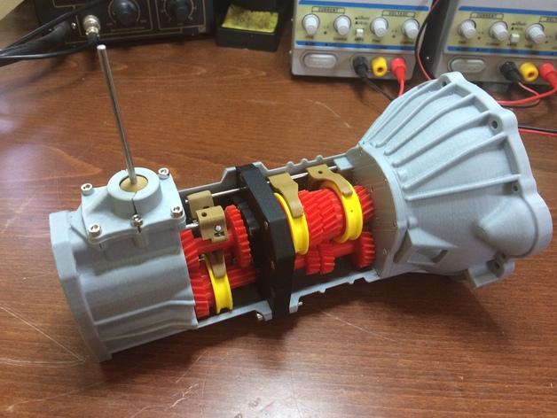
One of these latter instances comes in the form of a 3D printed 
5-speed transmission for a Toyota 22RE engine, created by a mechanical engineer named Eric Harrell of Santa Cruz, California. Not only does it look legitimate, but it also is completely functional.

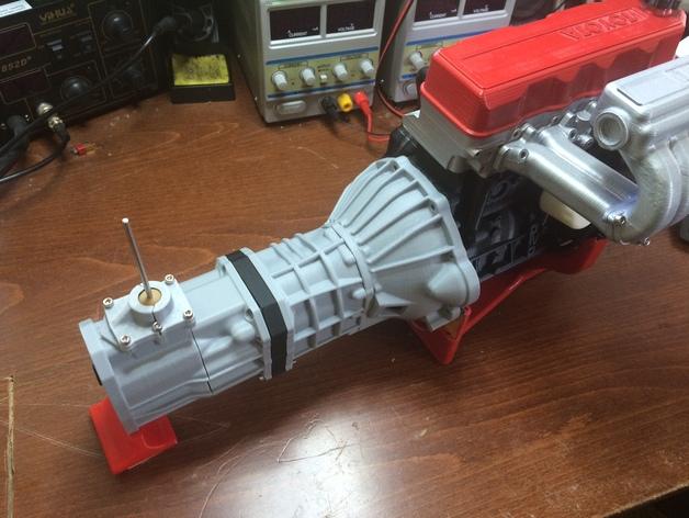
You may recall a story that we did back in January about a 
3D printed Toyota Engine. It was also designed by Harrell, after he completely reverse engineered a real Toyota 22RE engine. It received such a great reception from both Thingiverse users and the national media, that Harrell decided to take his creation one step further, providing this latest 3D printed transmission to complement the engine.

The two actually can be combined to create the ultimate piece of 3D printed machinery.

“I made the transmission due to the the success of my first upload, the 4 cylinder Toyota engine,” Harrell tells 3DPrint.com.  “The overall number of people that were interested was overwhelming.  I never thought that many people would be interested in it, yet actually print and build it, due to the shear complexity and print time involved. So far 8 people have made the engine and many more are in the process.”
transmission1
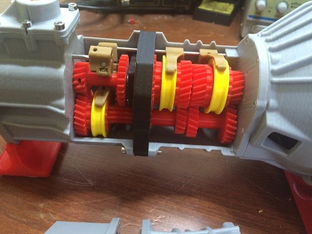
In all, it will take about 48 hours of print time to print out all of the individual pieces needed to assemble the transmission. Once the pieces have all been printed, they will need to be assembled using the diagrams that Harrell provides. He admits that it’s not an easy task to put the transmission together once the parts have been printed, but welcomes questions from anyone who has difficulty doing so.
Transmission and engine mated together.
“If one was to build either my transmission or engine, they would have a pretty good idea of how to put an actual engine together since these are modeled after real parts,” Harrell tells us. “Which is great, because most people that are interested in 3D printing would never get the opportunity to actually rebuild an engine or transmission.”
transmission4
While the majority of the transmission is 3D printed, there are some smaller parts which can not be printed on a desktop 3D printer, such as the 3mm rod, (18) 623zz bearings, (20) 3mm washers, and a few other small odds and ends like screws and bolts. At the same time, Harrell doesn’t ensure that all the parts will be ready to go off of the printer. Depending on the 3D printer used, some of them may need to be scaled up or down in order to fit together properly. Rather than scaling the parts, he also suggests that you could simply file them down where needed.
“The transmission works exactly like most manual transmissions found in any car or truck,” explained Harrell.  “However, I can barely explain how it works. It’s fairly hard to grasp unless you assemble one or see an animation of one opened up.”
Regardless of the time required for printing and assembly, this has to be one of the most incredible designs that we have come across yet on Thingiverse.  Most incredibly, Harrell tells us that it could absolutely be used in a real vehicle, since it is a scaled down version of the real thing.
What do you think about this incredible 3D printed Toyota transmission? Have you, or will you be 3D printing your own? Discuss in the 3D Printed Toyota Transmission forum thread on 3DPB.com. Check out the video below of the 3D printed transmission in action. 


Friday, March 13, 2015

A Map of all the Underwater Cables that Connect the Internet

As reported by the Vox: Cables lying on the seafloor bring the internet to the world. They transmit 99 percent of international data, make transoceanic communication possible in an instant, and serve as a loose proxy for the international trade that connects advanced economies.

Their importance and proliferation inspired Telegeography to make this vintage-inspired map of the cables that connect the internet. It depicts the 299 cables that are active, under construction, or will be funded by the end of this year.

In addition to seeing the cables, you'll find information about "latency" at the bottom of the map (how long it takes for information to transmit) and "lit capacity" in the corners (which shows how much traffic a system can send, usually measured in terabytes). You can browse a full zoomable version here (or a more modern version here).

The cables are so widely used, as opposed to satellite transmission, because they're so reliable and fast: with high speeds and backup routes available, they rarely fail. And that means they've become a key part of the global economy and the way the world connects.

Take, for example, the below map, which lets you slide between a 1912 map of trade routes and Telegeography's map of submarine cables today. The economic interdependence has remained, but the methods and meaning have changed:
The submarine cable map shows economic connections in less-developed countries as well. Cables between South America and Africa, for example, are much more scarce than trans-Atlantic and trans-Pacific routes:
Connections in the South Atlantic
Connections in the South Atlantic are scarce. (Telegeography)

Though cables to developing countries are expanding, they have a lot of work to do before they catch up. And Antarctica is left out completely (scientists down there get their internet from satellites).

The analogy between submarine cables and historic trade routes has a lot of caveats: trade routes were determined by geography as well as economic interests, and economic incentives were a lot different then than they are today. It would also be a mistake to overlook physical goods in favor of the internet (just look at those giant container ships). But both then and now, paths across the ocean require investment, trading partners on both sides, and a willingness to take risks. Sailors took the gamble in the past, and tech companies are taking it now.

Submarine cables get big investments from companies looking to explore their own modern trade routes
Submarine cables in Asia.
Submarine cables in Asia. (TeleGeography)

These cables carry information for the entire internet, including both corporate and consumer interests. That's why Google invested $300 million in a trans-Pacific cable system consortium to move data, Facebook put money into an Asian cable system consortium, and the finance industry invests just as much to shave a few milliseconds off trade times.

Other consortia regularly lay cables to transmit the consumer internet. Each group's control of a submarine cable is an advantage in the information exchange between countries.


Submarine cables are a 150-year-old idea with new potency
The process for laying submarine cables hasn't changed much in 150 years — a ship traverses the ocean, slowly unspooling cable that sinks to the ocean floor. The SS Great Eastern laid the first continually successful trans-Atlantic cable in 1866, which was used to transmit telegraphs. Later cables (starting in 1956) carried telephone signals.
A submarine cable.
Modern cables are surprisingly thin, considering how long they are and how deep they sink. Each is usually about 3 inches across. They're actually thicker in more shallow areas, where they're often buried to protect against contact with fishing boats, marine beds, or other objects. At the deepest point in the Japan Trench, cables are submerged under water 8,000 meters deep — which means submarine cables can go as deep as Mount Everest is high.

The optical fibers that actually carry the information are bundled within the larger shell of the cable:
A diagram of a submarine cable.
A diagram of a submarine cable. (Wikimedia Commons)
The components include:
  1. Polyethylene
  2. Mylar tape
  3. Stranded metal (steel) wires
  4. Aluminum water barrier
  5. Polycarbonate
  6. Copper or aluminum tube
  7. Petroleum jelly (this helps protect the cables from the water)
  8. Optical fibers
These cables move the videos, trades, gifs, and articles that bring the internet around the world in a matter of milliseconds. And that's the type of advantage any trader — digital or analog — could appreciate.

Frozen Lake Drag Race in Norway: Tesla AWD vs. Powerful Snowmobile (Video)

As reported by Tree Hugger.com: Drag-racing an all-wheel drive Tesla against a powerful snowmobile on a frozen lake in Norway might not be the most common of situations - how often are you going to do that? - but it's a fun test.

A Norwegian website did exactly that, pitting the Tesla P85D against a Lynx Boondocker 800cc (I think it's this one), with about 160hp and described as having "surreal" acceleration. Basically, it's a guy sitting on an engine, like a motorcycle, except made to have maximum traction on snow and ice, weighting only 230 kilos vs the 2,108 kilos of the Tesla, giving the snowmobile a better power-to-weight ratio.

Also note that the Tesla didn't have chains or studded tires, as Elon Musk points out:

"The drag race takes place on the ice rink at Tisleia in Gol , on a plowed strip of water. A thin layer of snow covers the ice." Who won? Find out here:

This is another example of why electric cars have the potential to be better than gasoline ones.

Electric motors react instantaneously, have flat torque curves, and can be monitored very precisely at all times. This means that a car's on-board computer can manage traction better than with a gasoline car, with its lag and mechanical links between engine and wheels. This is especially true with an all-wheel drive EV like the new Tesla P85D (all the "D" models are "dual motors", thus all-wheel drive). Each wheel only gets the exact amount of torque that it can handle without slipping, maximizing safety/performance in slippery conditions.

GPS and Snow Depth: When Mother Nature Got Stingy, this Ski Area Got Creative

Groomer and snow maker JP Silva utilizes GPS technology to measure snow depth while working through the night at Diamond Peak Ski Resort near Incline Village on March 6, 2015.  (Photo: Jason Bean/RGJ)
As reported by RGJ:After more than five years grooming runs and making snow at Diamond Peak Ski Resort it's obvious JP Silva has an innate feel for the terrain.

He can navigate the snowcat with ease even during a casual conversation with a rider, operating stick controls and monitoring screens and gauges to keep the diesel powered, roughly eight-ton vehicle level and grooming a smooth, corduroy pattern into the snow.

To hear Silva describe it he's got a near-spiritual connection to the mountain when he's operating the snowcat during one of his overnight shifts.

"It's like my Zen place," Silva, 32, said during a recent shift. "I'm out here practicing in my garden."

But even Silva's close relationship with the terrain isn't enough to effectively manage the snow at Diamond Peak which, like much of the Sierra Nevada, has been ravaged by a four-year drought that's shown no sign of abating. In fact, scientific evidence suggests climate change will contribute to even sparser snow conditions in the future.

That's why Diamond Peak is turning to satellite technology to help Silva and the other groomers and snowmakers at the ski area maximize the snow they get from Mother Nature and the stuff they make themselves.

It's the first ski area in North America to install SNOWsat technology on the terrain, in snowcats and in resort headquarters to actively manage snow depth as the groomers are running.

"It is like a video game," Silva said. "If I need a four-degree pitch I can instantly level and move the snow just right to get a four-degree pitch."

The system integrates satellites, software, wireless communication and mapping technology to give grooomers like Silva and others at Diamond Peak a live look at snow depth anywhere on the mountain. It also includes software for managing the fleet of snowcats by tracking location, idle time and other statistics.

But when it comes to managing ski conditions during an era of low snow it's the snow depth data that's critical to operators.
Grooming Supervisor Russ Mitchell, in cab, talks with fellow groomer JP Silva while working through the night at Diamond
Peak Ski Resort near Incline Village on March 6, 2015. (Photo: Jason Bean/RGJ)

"There are always pockets that accumulate snow," said John Glockhamer, marketing director for PistenBully, the company that makes the snowcats used at Diamond Peak and the SNOWsat technology. It's North American headquarters are in Reno.

"You may have a puddle of eight-feet of snow and 30 yards up on the ridge you have three inches," Glockhamer said.

The SNOWsat helps by measuring snow depth and displaying it on monitors where snowcat operators and resort managers can see it. It's a high tech version of the previous measuring system, which involved ski patrollers working throughout the day to use sticks to measure and record snow data.

It works by using a computerized, three dimensional map of the mountain without snow as a baseline. Then sensors mounted on snowcats allow satellites and a base on the ground to pinpoint the location of each vehicle that's outfitted with the technology.

Grooming Supervisor Russ Mitchell shows off the tiller on his snowcat while working at
Diamond Peak Ski Resort near Incline Village on March 6, 2015. 
(Photo: Jason Bean/RGJ)
By measuring how far the snowcat is above bare ground the system can tell operators the snow depth with an accuracy of less than two inches.

Glockhamer said previous attempts to use technology to measure snow depth were often sonar-based. But the inconsistency of snow within the snowpack undermined the usefulness of that technology, which sends out pulses of sound and reads the echo to determine distance. Layers of ice and other inconsistencies in the snow could lead to inaccurate readings, Glockhamer said.

Satellite technology also had problems, he said. The big one is that most satellite location systems only track objects with an accuracy of a couple feet or meters.

When it comes to maintain snow conditions for resort skiing, "if you are accurate within two feet that doesn't mean anything," he said. "Especially this year when there is no snow, you need to know right down to inches."

By combining the ground-based unit and computer model of the mountain with the satellites SNOWsat improves three-dimensional location accuracy enough to be useful to groomers, Glockhamer said.

It's already in use in more than 100 locations in Europe, he said. And there's an expectation more North American ski areas will try SNOWsat or something like it, especially given how susceptible the winter resort industry is to disruption from climate change.

A spokeswoman for Diamond Peak, which is operated by the Incline Village General Improvement District, said the system cost about $100,000. The snow depth technology is on two of Diamond Peak's five snowcats. The fleet management system is on all five.


A groomer stands in front of his snowcat at
Diamond Peak Ski Resort near Incline
Village on March 6, 2015. 
(Photo: Jason Bean/RGJ)
Brad Wilson, general manager of Diamond Peak, said the technology allows workers to better anticipate thin spots in order to prevent them before they turn to bare spots and ruin a run. That's especially critical in the Sierra Nevada where springtime sunshine can make a bare spot grow exponentially in a matter of hours.

"You don't want to wait until you see a thin spot," Wilson said. "The last thing you want to do is have a thin spot open up, it just absorbs heat."


That's not much of a problem when the Sierra Nevada is having a traditional, at least for the 20th century, winter with a massive snowpack. But when conditions are thin, as they have been in recent years, better snow management is needed to extend the number of weeks and days skiers can play on the slopes.

"If you have a 12-foot base you could make a lot of mistakes and not have to worry about it," Wilson said. "When you are dealing with one, two, three, four-foot bases it makes a huge difference."


Thursday, March 12, 2015

Drone Vs. Volcano: How Robotic Flyers are Changing Exploration

As reported by WiredIt’s early morning on my second day at Marum Crater, and as I drift in and out of sleep, I try to place the incongruous buzzing that seems to have awoken me. I unzip the tent’s vestibule and peer outside, where a small drone hovers in the distance, four blades whirring in synchrony and small camera pointed back toward camp. “Let’s get going,” urges Simon Jardine, the man behind the joystick, punctuating his flyover with a well-intentioned cackle. “There’s a fiery pit of lava to go explore!”

For all his joie de vivre, Jardine is a master drone builder and pilot whose skills have produced remarkable footage for shows like Australian Top Gear, the BBC’s Into the Volcano, and a range of music videos. His company Aerobot sells camera-outfitted drones, including custom jobs that require unique specifications like, say, the capacity to lift an IMAX camera. From a sprawling patch of coastline real estate in Queensland, Australia, Jardine builds, tests, and tweaks his creations; the rural tranquility is conducive to a process that may occasionally lead to unidentified falling objects.

Simply put, if you’ve got a drone flying challenge, Jardine is your first call.

Sam Cossman, the adventurer who put this expedition together, got Jardine on board early in the planning process. “I met Simon on my first expedition to Vanuatu,” he recalls, “one morning when we had both awoken early to catch first light.” After leaving their respective trips and following each other’s work, the mutual admiration grew. “When I decided to return to the volcano,” says Cossman, “I knew Simon would be an integral part of the expedition because of his familiarity with the terrain, the extreme flying conditions, and his level of expertise.”

I take a final sip of tea, revealing a gravelly deposit of the pervasive volcanic sand at the bottom of the mug, and join Cossman and Jardine on the crater’s edge. We’re plotting an ambitious drone flight across the crater, one that will capture footage of the full scene with unprecedented detail. Plugging the resulting imagery into 3-D rendering software from Pix4D will generate a model of the tiered crater system, providing a key resource for geologists and hazard assessment teams who are working to understand more about the volcano’s fiery temperament.

“I have flown in some really crazy places,” says Jardine, recalling his past work in caves, around big waves, and underneath the Sydney bridge. But the vast scale, whirling winds, corrosive fumes, and intense temperatures of Marum Crater presented new challenges. The previous day, Jardine had taken the plunge into the crater itself in order to get footage of the lava lake at closer range than would be practical for human participants. “The bottom of Marum Crater was definitely the most insane place to fly a copter, especially a plastic one,” he says. “The hardest part of flying was the hot air rushing out and cold air getting pulled into the lake. The machine would surge forwards and I would pull back on the stick. Then the hot air would blow in my face 10 times hotter than a hairdryer, and I could see the copter blasting back at me, so I’d push forwards on the stick, and so on. It was like playing tug-of-war with a drunk drone.”

As a scientist, I was particularly encouraged by the idea of having additional vantage points. From the aerial perspective, it’s possible to quantify the thicknesses of past eruptive layers – the iron-rich red bands, the columnar basalts, the cobble conglomerate – to reconstruct the events that formed the crater. Filming my own sampling efforts was critical in assigning metadata to particular rocks. When a lava lake is gurgling a few meters away, time is of the essence, and making simple measurements is not practical. Information like the size and spatial distributions of recently erupted rocks, the precise distance from the eruption, and the relationship between rock color and age are all discernible from the drone and GoPro footage.

Looking forward, Cossman is also eager to use drones in a more exploratory sense. “We were initially on the hunt for a new vent and potential lava lake that we believed existed in a neighboring crater,” he recalls. “I believed the drones would carry a great sense of utility for our exploration by serving as our eyes in the sky for this unfamiliar terrain, helping to identify the new volcanic feature and to inform the safest and most direct descent route.” For now, that descent will have to wait, but when it does happen, it will likely be faster and more efficient – and thus potentially less hazardous – than previous efforts.

Jardine’s flight around, over, and through the crater was ultimately successful, though not without robotic casualties. One drone fell out of the sky and clattered down the rock wall, shedding propellers along the way. Many of the cameras and other electronics suffered from the pervasive acidic vapor, corroding over the course of hours. But after several flights that push the batteries, the navigation system, and Jardine’s skills to the limit, we’ve covered the entire kilometer-wide crater. The resulting 3-D imagery, shown below, represents the highest resolution map of the crater to date, and offers an alluring vision of the future of technology-assisted exploration.

Another fully immersive model – in which you can walk around the crater, leap down its vertical faces, and stand on the shore of the lava lake – is currently in the works. Says Cossman: “we’ve imported the high definition model it into a virtual environment, so I can literally invite people in and give them a virtual tour in real time.”

BeiDou Day Numbering Creates Leap-Second Issue

As reported by GPS World: During preparation of playback scenarios for the upcoming leap-second event taking place in June, engineers at Racelogic identified a potential pitfall for GNSS engineers.

The difficulty arises from the fact that BeiDou uses a different “day number” for the date to apply the leap second, compared with GPS and Galileo. GPS and Galileo use 1-7 as week day numbers, and BeiDou uses 0-6.

If this fact has been missed during development, then the result is that the leap second may be implemented a day early on GNSS engines that are tracking the BeiDou constellation, said Mark Sampson, product manager for Racelogic.

“We tested four different Beidou enabled receivers, from four leading GNSS companies, and none of them appeared to handle the Beidou leap second correctly. This included an engine which originates from China!” Sampson said. “We have since been in contact with two of these companies, who have confirmed that their hardware does have a bug in the leap-second code due to the numbering of the days.”

The error presents itself when the receiver is running on the BeiDou constellation alone, and when the date is June 29 of this year. In some cases, the BeiDou leap second will be adjusted from 2 to 3 seconds from midnight on June 29, which should in fact occur on midnight of June 30. This will result in an error for the reported UTC time of 1 second for the period of this day. In other cases, the leap second was not implemented at all when running on BeiDou alone.

“We have also checked the output of a BeiDou signal generator from a different simulator company, and this too uses the 1-7 range for the BeiDou leap-second date instead of the correct 0-6 range,” Sampson said. “This may explain why a number of commercial receivers appear to have been caught out by this issue.”

In order to help companies test for this problem, Racelogic has generated simulated RF data for June 29 and 30, starting 15 minutes before midnight. “We have two sets of files. One set contains BeiDou only signals and the other contains a combination of BeiDou and GPS signals,” Sampson said. “Note that on some of the receivers we have tested, when GPS is being tracked as well, the GPS leap-second message overrides the one coming from BeiDou and applies the leap second correctly.”

The scenarios are compatible with Racelogic’s LabSat3 triple constellation simulator, which is available on a free 15-day loan or can be purchased from Racelogic.