Search This Blog

Friday, September 19, 2014

Smartphone Movements Could Reveal Empty Parking Spots

As reported by MIT Technology Review: Researchers have come up with a novel way to find parking spots with your smartphone. It promises to be much easier than driving around looking for an empty space, and doesn't require the installation of pricey sensors or other methods for tracking available spots.

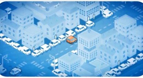
At the State University of New York at Buffalo, researchers built an app called PocketParker that does what they’re calling “pocketsourcing”—essentially, turning smartphones into passive sensors that track the location and movements of other users who've installed the app. A remote computer crunches the aggregate user actions and determines the likelihood that a lot has an open space. A paper about PocketParker was presented at the ubiquitous computing conference UbiComp in Seattle last week.

While some parking lots employ sensors to gather information about capacity, PocketParker works without any such infrastructure. It pulls parking lot data from OpenStreetMap and calculates the number of spaces in a given lot based on its dimensions. During a study, researchers found that they could predict the number of spaces to within 6 percent of the actual number.

The app uses the smartphone’s accelerometer to determine where a user is and gauges whether he’s looking for a parking spot based on his movements. If a user drives slowly through a parking lot without stopping, that signals that the lot is full. If a user displays movements typical of walking and then suddenly speeds up and leaves the lot, that signifies that he likely just got into his car and drove away. The app calculates this in the background. “There should be no interaction required,” says SUNY Buffalo computer science professor and paper coauthor Geoffrey Challen.

For their study, the researchers had 105 smartphones users around Buffalo test out the app over a month and a half, generating a total of 10,827 car arrivals and departures. Checking their work with cameras they installed at the lots they tracked in the study, the researchers found they were able to correctly predict how many spaces were available 19 out of 20 times. “Our goal is to prevent people from circling,” Challen says.  

There are a few problems with the approach. One obvious one is that PocketParker can’t account for drivers who aren’t using the app. Another is that a user might leave his phone in the car, drop his car off and get in another car, or he might not be searching for a parking space at all but be picking up a friend. “Until you have enough people using it, apps like this tend not to work well,” Challen says. “It’s stuck in this chicken-and-the-egg problem.”  

Because of this, Challen doesn’t envision PocketParker as a standalone app. Instead, it could be featured within a mapping app—similar to the way Google Maps integrates traffic data into its app. Challen believes that if a feature like PocketParker were flipped on in the background, it would quickly collect enough data to make far better assumptions about parking spot availability.

BlackBerry has yet Another Porsche Design Smartphone Coming Next Month

As reported by The Verge: BlackBerry is launching its next Porsche Design-branded smartphone, the P'9983, in October. Unlike the P'9982, its Porsche-emblazoned predecessor, the new P'9983 has a QWERTY keyboard — but just like a real Porsche, the P'9983 will likely be sold at a monumental markup.

The P'9983 has a 3.1-inch screen, 720 x 720 resolution display, and 64GB of internal storage. In an attempt to live up to its luxury branding, BlackBerry has used costly sapphire glass for the P'9983 — but only for the phone's pea-sized camera lens, not its display.

It also has its own PIN ID group, meaning fellow BlackBerry users can identify the person in the room they should be pointing and laughing at. BlackBerry hasn't set a price for the new model, but previous phones in the weirdly named series cost more than $2,000 when they launched.  Expect the P'9983 to cost similar.


Thursday, September 18, 2014

Scientists Twist Radio Beams to Send Data at 32 Gigabits Per Second, 30 Times Faster than 4G LTE

As reported by IB Times: Scientists from three international universities have succeeded in twisting radio beams in order to transfer data at the speed of 32 gigabits per second, which is 30 times faster than 4G LTE wireless technology in use today.

The researchers, led by Alan Willner, an electrical engineering professor with the University of Southern California Viterbi School of Engineering, successfully demonstrated data transmission rates of 32 gigabits per second across 2.5m of free space in a basement laboratory.

"Not only is this a way to transmit multiple spatially collocated radio data streams through a single aperture, it is also one of the fastest data transmission via radio waves that has been demonstrated," said Willner.

The research, entitled "High-capacity millimetre-wave communications with orbital angular momentum multiplexing" is published in the latest issue of journal Nature Communications.


An image showing the intensity of the radio beams after twisting
Of course this transmission speed is not as fast as what you can achieve if you twist light - Willner did this too, two years ago, and achieved data transmission speeds of 2.56 terabits per second - which is why the world is now moving towards fibre-optic internet networks. However, the scientists say radio is more reliable.

"The advantage of radio is that it uses wider, more robust beams. Wider beams are better able to cope with obstacles between the transmitter and the receiver, and radio is not as affected by atmospheric turbulence as optics," Willner said.

Millimetre waves occupy the 30GHz to 300GHz frequency bands.. They are found in the spectrum between microwaves, which take up the 1GHz to 30GHz bands, and infrared waves, which are sometimes known as extremely high frequency (EHF).

EHF can only be used over short distances such as a few kilometres due to high free space loss and atmospheric absorption.

However, more and more mobile operators are becoming interested in millimeter waves as they seek to create faster 4G LTE networks and beat congestion from too many users accessing the internet on their phones at one time. 

To achieve the high radio transmission speeds, the researchers passed each radio beam, which was carrying its own independent stream of data, through a "spiral phase plate" to twist it.

The radio beam turned into an orthogonal DNA-like helical shape which was untwisted at the other end of the room by the radio receiver.

"This technology could have very important applications in ultra-high-speed links for the wireless 'backhaul' that connects base stations of next-generation cellular systems," said Andy Molisch, a wireless systems researcher at USC Viterbi who co-designed and co-supervised the study with Willner.  

Next, the researchers will attempt to extend the twisted radio beams' transmission range and capabilities. The technology could have potential applications in data centers, where large bandwidth links between computer clusters are required.

Cell-Phone Data Might Help Predict Ebola’s Spread

As reported by MIT Technology Review: A West African mobile carrier has given researchers access to data gleaned from cell phones in Senegal, providing a window into regional population movements that could help predict the spread of Ebola. The current outbreak is so far known to have killed at least 1,350 people, mainly in Liberia, Guinea, and Sierra Leone.

The model created using the data is not meant to lead to travel restrictions, but rather to offer clues about where to focus preventive measures and health care. Indeed, efforts to restrict people’s movements, such as Senegal’s decision to close its border with Guinea this week, remain extremely controversial.

Orange Telecom made “an exceptional authorization in support of Ebola control efforts,” according to Flowminder, the Swedish nonprofit that analyzed the data. “If there are outbreaks in other countries, this might tell what places connected to the outbreak location might be at increased risk of new outbreaks,” says Linus Bengtsson, a medical doctor and cofounder of Flowminder, which builds models of population movements using cell-phone data and other sources.

The data from Senegal was gathered in 2013 from 150,000 phones before being anonymized and aggregated. This information had already been given to a number of researchers as part of a data analysis challenge planned for 2015, and the carrier chose to authorize its release to Flowminder as well to help meet the Ebola crisis.

The new model helped Flowminder build a picture of the overall travel patterns of people across West Africa. In addition to using data from Senegal, researchers used an earlier data set from Ivory Coast, which Orange had released two years ago as part of a similar conference (see “Released: A Trove of Data-Mining Research from Phones” and “African Bus Routes Redrawn Using Cell-Phone Data”). The model also includes data about population movements from more conventional sources, including surveys.

Separately, HealthMap, a team based at Boston Children’s Hospital, has produced an animation of the epidemic’s spread since March, based on records of when and where people died of the disease.

Bengtsson cautions that the model is essentially a first draft, and that it’s based on historical movements, so it does not take into account how people may have changed their behavior in response to the recent crisis. Ideally, he adds, it would include real-time data. But “in countries that already have epidemics,” he says, “this is the best estimate we can do of what mobility will look like. This can give the sense of the radius people tend to travel around.”

Ebola is transmissible via bodily fluids during an incubation period of between two and 21 days, during which victims may not know they are infected. That makes it particularly important to know where people are going and where they’ve been.

Mobile phones—which are ubiquitous even in poor countries—can play a key role. All cell phones “ping” nearby towers with a unique ID number to announce their presence. In this way, mobile carriers amass huge databases containing fine-grained information on population movements and social patterns.

The application to public health is compelling. Caroline Buckee, a Harvard epidemiologist who also worked with Flowminder to develop the West African model, has demonstrated how such data can show where people have gone after leaving a hot spot, suggesting where a disease cluster will crop up next (see “35 Innovators under 35: Caroline Buckee” and “Big Data from Cheap Phones”).

Last year Buckee demonstrated how cell-phone data could aid in fighting malaria by revealing where to focus mosquito eradication efforts. Previously, researchers trying to model mobility relied on techniques like counting heads at bus stations and asking sick people where they’d been traveling.

There’s no indication thus far that health officials are using the Flowminder model, which was released Wednesday. While public health agencies are interested in the topic, Bengtsson says that agencies such as the World Health Organization didn’t ask the researchers to develop the model or work with them to do so.

Emmanuel Letouzé, cofounder and director of Data-Pop Alliance, which is working on similar projects, says the approach holds promise. “If mobile carriers provide all the data at a very granular level, the value you can extract is huge,” says Letouzé, a visiting scholar at MIT’s Media Lab. Nevertheless, he says, “the privacy concerns are even more salient.” That is because such data reveal detailed social and business connections and location information, which can often be linked back to individuals.

GPS Technology Shaves Minutes Off Emergency Response Time

As reported by KRCU: Rural fire departments have found a way to improve their emergency response time by using GPS technology. By having the GPS coordinates of fire hydrants and other crucial tools, volunteer firefighters are able to shave minutes off their emergency response time.

Missouri’s acting state fire marshal Greg Carrell said firefighters in rural areas deal with the same type of challenges as firefighters is metropolitan areas.

“You cover a very large area, an area that changes frequently and so it’s very difficult to know every location in your jurisdiction and know exactly where it’s located, even based on a street address,” Carrell said.

He added that in cases of natural disaster, such as the tornado in Joplin, landmarks and street signs may be gone and the use of GPS becomes crucial in order to save lives.

Frank Wildeman, natural resources engineer with the University of Missouri Extension, worked with a Boy Scout troop in Fredericktown, Mo. to create a fire hydrant map. The project, using GPS units and computer mapping, located about 300 fire hydrants.

“The ability to be able to put in a coordinate, and know that you are responding to an area where a fire hydrant is without having to guess whether it’s at the corner of a certain street or halfway down the block is one of the great uses for GPS,” Carrell said.

By having all the fire hydrants GPS located, emergency responders can find them more easily and this information allows them to leave the firehouse with the right equipment they need to go to work.

“With that information loaded on to a computer map, they could tell which fire hydrants were located close to the fire call, how much hose it would take to get there, they also had information on what type of fire hydrant it was and what kind of hose connector it would take to hook up to it,” Frank Wildeman said.

The fire hydrant map helps volunteer firefighters  in Fredericktown and emergency personnel in nearby communities whenever they are deployed to bring additional help.

The GPS helps reduce the response time because the firefighters receive the information on their pagers and on their smartphones. Volunteer firemen can save time getting to the site and the fire truck can leave the fire house a little bit quicker.

“Just a couple of minutes make a big difference on a big fire,” Wildeman said.

Property owners benefit from the improved response time because their insurance rates decrease.


“By having the GPS locations of fire hydrants and being able to use GPS to deploy themselves and get on site several minutes quicker, it improves their fire insurance rating in the community and the homeowners end up paying a lot less for their homeowner insurance,” Wildeman explained.

Search and rescue techniques using GPS units have also been developed. It allows rescuers to deploy themselves to a particular location where they can plan the direction of travel they use during their search activity.

“We can actually, on the GPS units, record where they have traveled so that we can make sure that we actually did search the area that we planned to search,” Wildeman said.

Most current cellphones have a GPS chip that transmit the location of a person when they call 911.

“The firefighters are able to take that location from the call for help and plan their approach to that location and plan how they are going to search for that person once they get closer to the location,” Wildeman said.  

Without that, the rescuers have to do a much broader search. As an example, Wildeman said the Cherokee Pass Volunteer Fire Department now use only 25 percent of the time they used to take for search and rescue interventions. While it used to take them four times longer to find someone, the fact that the GPS signals are sent directly to the emergency dispatch allow them to find a lost person much faster.

Fire departments in Madison County are looking at using, in addition to pagers, text messages to alert their volunteers that they have an event to report to. The text will give them the event’s location and allow them to send a signal back to the firehouse to let them know how far away they are from the event and how long it will take them to respond to that call. This helps firefighters quickly arrive at the scene.

Wednesday, September 17, 2014

New Amphibious Marine Corps Vehicle Can Carry 3 Tanks Up To 200 Nautical Miles

As reported by Industry TapThe Ultra Heavy-Lift Amphibious Connector (UHAC) is the latest innovation from the Marine Corps Warfighting Lab, in conjunction with the Office of Naval Research, which is essentially a monster amphibious assault vehicle.  

The UHAC began testing in early July and can do a whole slew of things, including landing multiple tanks at once and bringing ashore equipment, vehicles and troops.
UHAC Features:
  • Carry payloads up to 190 tons
  • Speeds up to 20 knots
  • Climb sea walls up to 10 feet in height
  • Capable of carrying three battle tanks up to 200 nautical miles
Cpl. Matthew J. Bragg/USMC

Tuesday, September 16, 2014

Space Race: NASA Awards Contracts to Boeing, SpaceX

As reported by ABC News: NASA awarded contracts today to Boeing and Elon Musk's SpaceX to ferry astronauts to and from the International Space Station, signaling the agency's return to manned spaceflight after the end of the space shuttle program.

"This is the fulfillment of the commitment President Obama made to return human space flight launches to U.S. soil and end our reliance on the Russians," NASA administrator Charles Bolden said.

The winning designs will end U.S. dependence on the Russian Soyuz for transportation back and forth to the International Space Station.

The announcement came after an expensive and ferocious competition to determine which companies would be tasked with building the next era of spacecraft.

Boeing’s contract could have a value of $4.2 billion while SpaceX’s deal is valued at $2.6 billion, according to Kathy Lueders, the program manager of NASA’s Commercial Crew Program.

Lueders said having two contracts will help NASA make sure it stays on track to meet its 2017 goal of manned spaceflights.

The Commercial Crew Program was designed by NASA to replace the retired space shuttle, which was the workhorse of the agency's space program for over 30 years.

Boeing has invested in the CST 100 capsule, which would launch on an Atlas V rocket -- almost a turnkey proposition for NASA when you consider the company’s history in aerospace.


SpaceX has the advantage of already launching cargo spacecraft to the International Space Station and hopes to parlay that experience into a human version of its Dragon spacecraft.

Lueders said each company will be paid on the performance of key milestones. The biggest one: Boeing and SpaceX will have to successfully make manned flights to the International Space Station, where they will have to demonstrate their ability to deliver cargo, dock and then return safely to Earth.