Search This Blog

Tuesday, May 24, 2016

14 Galileo GNSS (GPS) Satellites Now in Orbit

As reported by GPS WorldThe Galileo satellite navigation system that will help Europe find its way in the 21st century now has 14 satellites in orbit after today’s double launch.

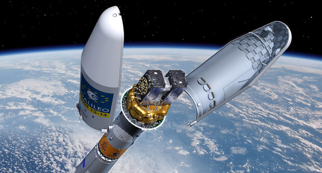
Galileos 13 and 14 lifted off together at 08:48 GMT (10:48 CEST, 05:48 local time) atop a Soyuz rocket from French Guiana.
This seventh Galileo launch went by the book: the first three Soyuz stages placed the satellites safely into low orbit, after which their Fregat upper stage hauled them the rest of the way into their target medium-altitude orbit.
The twin Galileos were deployed into orbit close to 23,522 km altitude, inclined 57.394 degrees to the equator, 3 hours and 48 minutes after liftoff. The coming days will see a careful sequence of orbital fine-tuning to bring them to their final working orbit, followed by a testing phase so that they can join the working constellation later this year.“Today’s textbook launch has added two more satellites to what has become Europe’s largest satellite constellation,” commented Jan Woerner, director general of ESA. “It was made possible by the fact that European industry’s manufacturing and testing of Galileo satellites has achieved a steady tempo.”
“Today’s launch brings Europe’s Galileo constellation halfway to completion, in terms of numbers,” remarked Paul Verhoef, ESA’s Director of the Galileo Program and Navigation-related Activities.
“It is also significant as Galileo’s last flight by Soyuz this year before the first launch using a customized Ariane 5 to carry four rather than two satellites each time – which is set to occur this autumn.
“Meanwhile, hard work is proceeding behind the scenes to ensure the worldwide Galileo system, including its far-flung ground stations, is reliable, secure and robust for the start of operational services to users.”
Full video replay of the launch is available here.
The launch was carried out from the purpose-built ELS launch complex at Europe’s Spaceport,. Total payload lift performance was estimated at 1,599 kg.
The flight had an early morning liftoff from the Spaceport – coming at precisely 5:48:43 a.m. French Guiana time. This Arianespace Soyuz mission was performed at the service of the European Commission, which is managing the Galileo program’s ongoing FOC (Full Operational Capability) phase. Design and procurement agent responsibilities have been delegated to the European Space Agency (ESA) on the commission’s behalf.
It is during the FOC phase that the Galileo network’s complete operational and ground infrastructure will be deployed. Today’s Soyuz mission — designated Flight VS15 — was Arianespace’s fifth overall carrying FOC spacecraft in sets of two. It follows one launch in 2014 (VS09), then three performed last year (VS11, VS12 and VS13). The medium-lift workhorse also lofted a total of four satellites in the program’s IOV (in-orbit validation) phase in 2011 and 2012.
The satellites orbited today — named “Danielė” and “Alizée” after winners of a European Commission-organized painting competition for children — are the 13th and 14th Galileo spacecraft overall to be orbited by Arianespace.
The spacecraft’s onboard payloads were supplied by UK-based Surrey Satellite Technology Limited (SSTL) — a company 99-percent owned by Airbus Defense and Space, which is an Arianespace shareholder, as well.
Israël acknowledged others that contributed to this latest Arianespace success, including State Space Corporation Roscomos and Russia’s industrial partners involved in the production and operation of Soyuz; along with the European support companies; the French CNES space agency; the ground contractors in French Guiana and Arianespace’s own teams.
Arianespace will conduct another launch for Galileo’s FOC phase later in 2016 — this time using an Ariane 5 and its heavy-lift capability to orbit a four-satellite payload. Two additional launches of the heavy-lift workhorse in 2017-2018 will bring total Galileo deployments to 26 spacecraft.

Engineers Just Smashed the Record for Fast Wireless Data Transmission

As reported by GismodoLike the idea downloading the contents of a DVD in less then 10 seconds without a cable in sight? That’s exactly what a team of German engineers can do, having broken the record for wireless data transmission using terrestrial radio signals.

A team of researchers from the Fraunhofer Institute for Applied Solid State Physics claims to have beaten the previous record for beaming data in this way by a factor of 10. To achieve the feat, they transmitted data on signals in the 71–76 GHz radio frequency band—which is usually used for terrestrial and satellite broadcasting.
But to squeeze in that amount of data requires an impressive signal-to-noise ratio, to avoid having to waste bandwidth on error-correction. So the team built a system of ultra-efficient transmitters and receivers. The transmitters are based on semiconductor chips made gallium-nitride, which provide a high-power signal that’s transmitted from a focused parabolic antenna.
The team beamed the signals between a 45-story tower in central Cologne and the Space Observation Radar in Wachtberg, 23 miles away. At the receiver, the researchers used special low-noise amplifiers built using indium-gallium-arsenide transistors. Their sensitivity allows them to detect incredibly weak signals.
The resulting speed of 6 gigabits per second has pretty obvious application. The researchers points out that a single transmission beam could be used to supply as many as 250 internet connections running at 24 meagabits per second to sites where it’s impossible to run a wired connection. While you might immediately think such a system would be best suited to, say, disaster zones, the researchers reckon it could even prove a “cost-effective replacement for deployment of optical fiber.”

Friday, May 20, 2016

New Space Station Orbiting The Moon By 2020 Announced

As reported by FuturologyOrbital ATK has unveiled a practical new proposal to build a near term man-tended outpost in lunar orbit that could launch by 2020 and be operational in time for a lunar link-up with NASA’s Orion crew module during its maiden mission, when American astronauts finally return to the Moon’s vicinity in 2021 – thus advancing America’s next giant leap in human exploration of deep space.

The intrepid offer by Orbital could be carried out rather quickly because it utilizes an evolved version of the company’s already proven commercial Cygnus space station resupply freighter as “the building block … in cislunar space,” said Frank DeMauro, Orbital ATK Vice President for Human Spaceflight Systems, in an exclusive interview with Universe Today. See an artist concept in the lead image.
“Our Cygnus spacecraft is the building block to become a vehicle for exploration beyond low Earth orbit,” Orbital ATK’s Frank DeMauro told Universe Today.
“We are all about supporting NASA’s Mission to Mars. We feel that getting experience in cislunar space is critical to the buildup of the capabilities to go to Mars.”
NASA’s agency wide goal is to send astronauts on a ‘Journey to Mars’ in the 2030s – and expeditions to cislunar space in the 2020s serve as the vital ‘proving ground’ to fully develop, test out and validate the robustness of crucial technologies upon which the astronauts lives will depend on later Red Planet missions lasting some 2 to 3 years.
Orbital ATK’s lunar-orbit outpost proposal was announced at an official hearing of the US House of Representatives Subcommittee on Space on Wednesday, May 18, by former NASA Astronaut and Orbital ATK President of the Space Systems Group, Frank Culbertson.
“A lunar-orbit habitat will extend America’s leadership in space to the cislunar domain,” said Orbital ATK President of the Space Systems Group, Frank Culbertson.
“A robust program to build, launch and operate this initial outpost would be built on NASA’s and our international partners’ experience gained in long-duration human space flight on the International Space Station and would make use of the agency’s new Space Launch System (SLS) and Orion deep-space transportation system.”
The idea is to assemble an initial crew-tended habitat with pressurized work and living volume for the astronauts based on a Cygnus derived vehicle, and have it pre-positioned and functioning in lunar-orbit by 2020.
As envisioned by Orbital ATK, the habitat would be visited during NASA’s first manned mission of SLS and Orion to the Moon known as Exploration Mission-2 (EM-2).
The three week long EM-2 lunar test flight could launch as early as August 2021 – if sufficient funding is available.
The goals of EM-2 and following missions could be significantly broadened via docking with a lunar outpost. And Orion mission durations could be extended to 60 days.
NASA hopes to achieve a launch cadence for Orion/SLS of perhaps once per year.
Therefore autonomy and crew tended capability has to be built in to the lunar habitat right from the start – since crew visits would account for only a fraction of its time but enable vastly expanded science and exploration capabilities.

Thursday, May 19, 2016

Uber Shows Off its First Self-Driving Car

As reported by Engadget: Uber's foray into the world of self-driving vehicles will become a lot more visible in the coming weeks after the company confirmed its first autonomous car will officially hit the streets of Pittsburgh. The prototype -- a hybrid Ford Fusion -- will assist the company in collecting mapping data while putting its self-driving capabilities to the test. Uber's Advanced Technologies Center (ATC), which is headquartered in the city, has equipped the car with a variety of sensors including radar, laser scanner and high-resolution cameras, but a human rider will be present at all times.

While this isn't the first time we've heard about Uber's prototype -- it was spotted cruising the city's streets by the Pittsburgh Business Times last year -- it is the first time the company has publicly shared news of its plans. In a blog post, Uber says that the development of its self-driving technology will mean "less congestion, more affordable and accessible transportation, and far fewer lives lost in car accidents."

Uber has already gained permission from local authorities to test its car and will use the road miles to ensure it can deal with pedestrians, cyclists and other drivers. It thinks Pittsburgh's streets will also provide the right environment for its vehicle to learn from, with its differing road types, traffic models and weather conditions. It also helps that Carnegie Mellon is on the doorstep, allowing the company to gather experience from engineers who have already built advanced autonomous robots and Mars rovers.

The end game, it appears, is to be one of the first to market with a fleet of for-hire vehicles. General Motors will invest $500 million in Lyft to help beat Uber to the punch and Google is forging ahead with the development of its own driverless car with the idea to spin the business off into an autonomous taxi service. Each entrant needs thousands of road miles before their vehicles are ready to take passengers, suggesting you'll see many more driverless prototypes in the wild in the months ahead.

Tuesday, May 17, 2016

Google Veterans Head Off on Their Own to Work on Self-Driving Truck Kits

As reported by The VergeFormer employees of Google, Apple, Tesla, Cruise Automation, and others — 40 people in total — have formed a new San Francisco-based company called Otto with the goal of turning commercial trucks into self-driving freight haulers. Prominent staffers include former Google Maps lead Lior Ron and Anthony Levandowski of Google's self-driving car team.
Rather than building their own trucks, Otto is hoping to make hardware kits for existing truck models that would either be installed by service centers, or possibly at the factory if the company is able to forge manufacturer partnerships. Unlike Google's self-driving car project, Otto would at least initially focus on highway driving, which account for the overwhelming majority of a typical truck route; the human drivers would still handle surface streets, loading, unloading, and the like. Right now, the company is testing with the Volvo VNL 780, but hopes to work with many so-called Class 8 trucks, which are the largest, heaviest trucks on American roads.
A FOCUS ON HIGHWAY DRIVING
If the name Anthony Levandowski sounds familiar, there's a good reason: his work on autonomous driving pre-dates Google's, and he served as the central character in a sprawling profile of the self-driving car project in The New Yorker several years ago. By all appearances, Otto has assembled a deep bench of self-driving expertise at a time when the field's best engineers are being offered enormous amounts of money by Tesla, Apple, and others, perhaps a testament to the pull that Levandowski brings to the table.
Many of Otto's founders have done well for themselves over the years, and it shows: the company is entirely self-funded right now without any external investment. (In the wake of the reported $1 billion Cruise Automation sale to General Motors, I ask Ron if the plan is to get acquired, but he's insistent that they're focused on bringing a product to market.) Even George Hotz's scrappy upstart Comma.ai has recently taken on venture funding from Andreesen Horowitz.otto-02
There's no price or timeline for Otto's commercial product — they say it'll be a "small fraction" of a truck's $100,000 to $300,000 sticker — but that's probably just as well, considering the murky regulatory environment. Levandowski says that apart from contested California regulations requiring steering wheels and pedals, there's nothing on the books banning self-driving cars as long as a human is in the vehicle (which Otto's product would always still require). Still, USDOT, NHTSA, and others are deep in the mix on forming rules around self-driving vehicles with a proposed framework expected later this year. Regardless, the bigger immediate concern for Otto might be rules around how many hours truck drivers can operate their rigs per day; in theory, an Otto-equipped truck might be able to safely operate for many more hours than a human who is always in full control, but Ron says they'll have to work with regulators to prove that out.Otto isn't alone in trying to automate big rigs. Daimler and Volvo Trucks have both demonstrated self-driving systems in recent months, but Levandowski doesn't sound worried about those efforts. "I think the trucking folks are doing a great job, and eventually they would probably solve the problem. But a company that is used to building trucks is not well structured to solve a technology problem," he says. "I'm not trying to dismiss them in any way, I think it's fantastic what they're doing. But I think it's a different time-frame and objectives as to what we're trying to solve and what they're trying to solve."
He also notes that manufacturers' systems would require all-new trucks, unlike Otto, which could be retrofitted. "If you need to replace all of your trucks to get the technology on it, the rate of penetration you'll be able to have is pretty low. Trucks last ten years, a million miles."

DARPA Wants an Underwater GPS System for Seafaring Robots

As reported by WiredWE WOULD BE lost without GPS. The Global Positioning System constellation of satellites started life as a military project, but now enables turn-by-turn directions in the palm of your hand, and confidence that it’s almost impossible to get lost as long as you can see the sky.

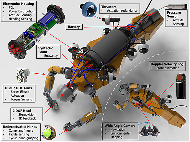
Underwater, it’s a different story. GPS doesn’t penetrate the briny deep, so Darpa, the Pentagon’s research arm, wants a system that will keep the robots plumbing the oceans on the map, and it’s asking for proposals from industry. The proposed solution also wins this week’s award for best military acronym: “Posyndon,” for Positioning System for Deep Ocean Navigation.
“What they are trying to do here is revolutionize underwater navigation in a way that is similar for what GPS did for above water,” says Neil Adams, director of defense systems at Draper, the non-profit R&D lab that’s working on an answer.
GPS satellites use very high frequency radio waves (in the L band, between one and two GHz), which can’t penetrate more than a few inches of sea water. To navigate, today’s unmanned underwater vehicles (UUVs), like some submarines, usually rely on dead-reckoning: They start out with an accurate fix on their location, then keep track of where they are, based on how far they’ve travelled, how fast, and in which direction.
That works okay for short trips, but long voyages demand the occasional GPS lock. That means popping to the surface, where military vehicles are vulnerable to detection. And dead reckoning requires expensive, power-hungry inertial measurement units. So, yeah, it’s not an ideal system.
A far better technology for underwater communication is acoustic signals—sound waves—at very low frequencies that travel well over long distances. Instead of satellites transmitting radio frequencies, an underwater GPS system could use a constellation of acoustic transmitters—powered underwater beacons, tethered to the seafloor, sending pings that propagate through the water.
A network of transmitters will allow a UUV to hear signals from several beacons at once and triangulate its position—the way our phones listen for signals from multiple GPS satellites. Now Darpa wants someone to find an appropriate type of acoustic technology, and figure out how many beacons you’d need to give good coverage across an entire ocean basin.
The ocean isn’t the easiest place to work. Posydon’s designers will have to cope with noise pollution, avoiding interference from and with all the other sources of sound in the oceans we make through shipping, drilling, and military exercises.  And they need a decent enough data transfer rate to be able to communicate meaningful information to drone-mounted nav systems. Even subtle changes in water temperature can alter the speed of sound. If the signals sent out from the beacons are going to be reliable enough for navigation, whoever’s running things will need a detailed understanding of how the waves propagate through seawater. Draper plans to start with high-fidelity computer “virtual-ocean” models to figure that out, and back it up with real-world tests.
Adams says any proposal will be cognizant of wildlife concerns. Animals like whales, which sound to communicate over long distances, may suffer from the noises humanity already makes. “We had to submit environmental assessment information, and it’s all well within the acceptable parameters,” he says. The proposal states “Darpa intends that execution of the Posydon program obey all applicable laws and regulations protecting marine life.”
Other researchers looking at this question are interested in bathymetric navigation—the comparison of scans of the ocean floor with known maps. Sonar or LIDaR can be used to do that, but both require a line of sight, and for the vehicle to be actively transmitting. With an acoustic system, the vehicles themselves would be passive listeners, waiting for pings. That level of stealth could be vital in military applications.
Civilians, too, could benefit from a reliable way to navigate underwater. Scientific and commercial research missions using UUVs could be easier and quicker, if the vessel didn’t have to regularly surface. That could happen soon: Darpa wants to see at-sea demonstrations by 2018. If it has its way, there soon won’t be anywhere on the planet where you can still get lost.

Friday, May 13, 2016

NASA Spacecraft Measure Magnetic 'Explosions' That Drive Space Weather

As reported by The VergeFor the first time, NASA spacecraft have measured the strange interactions between the Sun’s and Earth’s magnetic fields that are linked to explosive space weather events high above our planet’s surface. The phenomenon, known as magnetic reconnection, can disrupt satellites and telecommunications systems on our planet. Understanding how it works can potentially help researchers predict such space weather episodes and reduce their destructive side effects.
Magnetic reconnection occurs when the magnetic fields of the Earth and the Sun connect and release intense bursts of energy toward our planet. Scientists have known about these interactions for decades and have linked them to geomagnetic storms, which trigger brilliant aurorae near the Earth's poles. But because such storms can also impact our technology, scientists have been interested in figuring out the underlying physics of magnetic reconnection in space. Today's study, published in the journal Science, confirms a lot of what researchers suspected about the process, but also revealed data the researchers did not expect.
THE MAGNETIC FIELDS OF THE EARTH AND THE SUN CONNECT AND RELEASE INTENSE BURSTS OF ENERGY
Reconnection takes place at the outer edges of the Earth's magnetic field, which is known as the magnetosphere. This field is thought to be generated by liquid iron flowing deep within the Earth’s core. The twisting and turning of this hot metal creates an electrical current, which ultimately produces a charged magnetic field that extends between 40,000 and 370,000 miles around Earth.
The magnetosphere acts like a protective barrier and shields our planet from high-energy solar winds, which would otherwise strip away the gases in our atmosphere and kill life on Earth. The solar winds are created by the Sun's outer atmosphere, which is so heated that it's constantly sending out streams of highly energized, fast-moving particles toward Earth. These charged winds create their own magnetic fields, which clash against our planet's magnetosphere.
Normally, the two magnetic fields oppose each other and move in different directions. But every so often the magnetic field lines switch and connect with each other. That’s called a magnetic reconnection event. "When the two magnetic fields link up, then that allows the solar energy to flow straight into the magnetosphere," said study author Jim Burch, vice president of the space science and engineering at the Southwest Research Institute. "It sets the entire field in motion." The excited particles from the Sun stream into the magnetic field lines of Earth, transferring energy into the magnetosphere.

To study these explosive reconnections directly, NASA launched the Magnetospheric Multiscale, or MMS, mission in March of 2015. The project involved sending four identical spacecraft into orbit around Earth. In space, the probes are situated in a pyramid formation, so that they can study magnetic reconnection in three dimensions.
Instruments onboard the MMS spacecraft were able to precisely detect the movement of electrons during a reconnection event on October 16th, 2015, taking measurements once every 30 milliseconds. This way, the researchers were able to observe how energy was transferred. The data also revealed the behavior of the electrons during magnetic reconnection, showing how fast the particles moved and the directions in which they flowed. The electrons mostly followed the same patterns that researchers predicted.
"This is valuable insight," said Amitava Bhattacharjee, a professor of astrophysical sciences at Princeton University, who was not involved in the study. "It's testing past theory and is certainly bringing to light that certain features were in fact predicted by theory."
LEARNING MORE ABOUT MAGNETIC RECONNECTION MEANS SCIENTISTS CAN POTENTIALLY KNOW WHEN IT IS GOING TO HAPPEN
But during their observations, the researchers also found that the electrons behaved in unexpected ways they had not theorized. That provides more incentive to keep studying magnetic reconnection, the authors write. And by understanding more about the process, scientists can potentially know when magnetic reconnection is going to happen. "If you understand the underlying physics that drives space weather, I expect you can do a better job of predicting storms," said Burch.
That means we could someday know when geomagnetic storms are going to occur, allowing us to take the necessary steps to minimize space weather's effects on our technology.