Search This Blog

Friday, May 23, 2014

A Leak Seems To Have Let A 'Significant' Amount Of Seawater Into SpaceX's Dragon Cargo Ship

As reported by Business Insider: A "significant amount of water" was found inside the SpaceX Dragon cargo ship after it came back to Earth from the International Space Station on Sunday, Aviation Week reports.  

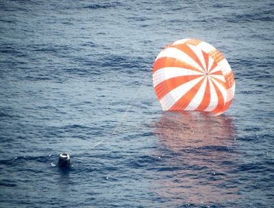
The Dragon capsule, currently the only spacecraft that can bring items from the space station back to Earth, splashed down into the Pacific Ocean about 300 miles west of Baja California on May 18.

The capsule returned to Earth with more than 3,500 pounds of science experiments and other items, including a freezer filled with research samples, NASA said.

Although the source of the water was initially thought to have come from some of the samples, NASA officials now believe there was some kind of breach in the spacecraft, causing seawater to spill inside.
The discovery was made when the Dragon hatch was opened at the port in California, space station deputy manager Dan Hartman said in a mission overview briefing. "It has not caused us any impacts that we know of," Hartman said.

There were "several gallons" of water in the cargo ship, according to SpaceFlightnow. Sources told Aviation Week there was more water "than could be accounted for by a burst water-transport bag," which is why officials think the water may have come from the ocean.  


The bulk of the cargo is now on its way back to handling facilities in Houston and the Dragon spacecraft is headed for McGregor, Texas.

The Dragon was launched on a Falcon 9 rocket to the space station on April 18, fulfilling its third of 12 resupply missions required under their $1.6 billion contract with NASA.

A NASA official confirmed to Business Insider that water was found inside the capsule, but said there was no indication of damage to any of the NASA cargo or other payload inside.

"When we started unloading cargo, we noticed our bag was intact," Hartman told Spaceflightnow. "They had some kind incursion through a port or a relief valve. They're off investigating it." 

According to Spaceflight, "Hartman said the Dragon returned in rough seas, which may have contributed to the water spilling inside."


Thursday, May 22, 2014

China Plans to Complete BeiDou GNSS Satellite Launches Ahead of Schedule

As reported by InsideGNSS: China’s BeiDou will accelerate the pace of its development, even as the world’s other three GNSS systems are experiencing delays and difficulties, according to speakers in the opening session of the China Satellite Navigation Conference (CSNC 2014) today (May 21) in Nanjing.

Ran Chengqi, director of the China Satellite Navigation Office, announced that with the launch of a new generation of satellites beginning next year, BeiDou expects to complete its planned Phase III several years ahead of schedule — by 2017 rather than 2020.

BeiDou Phase III includes the migration of its civil Beidou 1 or B1 signal from 1561.098 MHz to a frequency centered at 1575.42 MHz — the same as the GPS L1 and Galileo E1 civil signals — and its transformation from a quadrature phase shift keying (QPSK) modulation to a multiplexed binary offset carrier (MBOC) modulation similar to the future GPS L1C and Galileo’s E1.

The faster completion of China’s GNSS seems less surprising in the context of its rapid development of its ground and space segment since announcing BeiDou in 2007.

Meanwhile, launch of the first GPS III satellite with the L1C signal will not occur until 2016, and completion of the next-generation operational control segment  (OCX) is now slated for 2017, a couple of years later than originally planned. Galileo has also reduced its expectations for launch of its full operational capability (FOC) satellites to four by the end of this year, with the first launch date slipping from June to August and the second now expected in the November/December time-frame.

In a brief update on Russia’s GNSS, Sergey Karutin, head of the GLONASS PNT Information and Analysis Center, said GLONASS an interface control document (ICD) will be published this year describing the “full family of CDMA signals in all three [frequency] bands” that will be broadcast as part of the system’s modernization. One of those bands will be centered at the same 1572.42 MHz slot as GPS L1, Galileo E1, and Phase III BeiDou B1, while the legacy FDMA signals will continue in a relatively wide swath of spectrum at 1602 MHz and higher.


The second GLONASS K1 satellite will launch before the end of this year and the first of the K2 generation that will transmit the CDMA signals is now in production, Karutin said.

David Turner, deputy director of the U.S. State Department’s Office of Space and Advanced Technology, reported that the United States and China had established a bilateral working group on GNSS cooperation as one of the outcomes of a meeting of delegations from the two countries in Beijing on Monday (May 19, 2014). The working group will address such issues as civil service provision issues such as interoperability, service monitoring, interference detection, spectrum protection, and civil aviation applications. 

California OKs Self-Driving Car Rules

As reported by PCMag: The California Department of Motor Vehicles this week approved new rules that govern autonomous vehicle testing in the state.

Come Sept. 16, local residents may see more self-driving cars on California roadways, but don't expect to spot cars rocketing down the highway with an empty driver's seat just yet. For now, any company testing an autonomous vehicle must have a trained driver behind the wheel, ready to take over in the event of a malfunction, and at least $5 million worth of liability insurance.

The rules—and there are many of them—are almost textbook-like in their rigidity, but do a fair job of covering all aspects of state and test driver responsibilities.

An operator must be in the driver's seat, monitoring the vehicle's operations "and able to take over physical control of the vehicle." So, no napping, reading the paper, or FaceTiming.  

Additional requirements include extensive identification of the autonomous vehicle, as well as proof that the "driver" is on the company's payroll and has met all state-required qualifications—including passing the training program.

And, just like earning a traditional driver's license, all self-driving cars must first be tested in a controlled environment before hitting the open road.

The California DMV will start accepting applications for the program on July 1. A $150 annual processing fee covers up to 10 self-driving cars and 20 test drivers. Additional cars or warm bodies are $50.

This week's announcement has been in the works since December, when the DMV first circulated regulations for public use of autonomous vehicles. It held a public hearing in January, and on Monday approved the rules.  

The rules only cover manufacturer testing of self-driving cars. Rules regarding public use of autonomous vehicles are still in development at the DMV and are expected to be adopted by Jan. 1, 2015.

Mountain View-based Google has been one of the most prominent supporters of self-driving car tech. Recently, the search giant said it had logged almost 700,000 autonomous miles.  

Google was a big supporter of California legislation passed in 2012 that allows the technology. With Google execs present, Gov. Jerry Brown signed into law a bill that established safety and performance standards for self-driving cars in the state; Nevada also passed similar legislation.

Will Google’s Self-driving Cars Suffer From “Map Anxiety”?

As reported by IEEE SpectrumA week ago, Google held a press briefing at its expansive campus in Mountain View, California, aimed at showing off the progress it has made in its drive toward producing a self-driving car. The results, according to all who witnessed the company’s fleet of Lexus SUVs make their way around the streets of Mountain View without so much as a hiccup, were, in a word, impressive. (Well, The New York Times John Markoff called it “boring,”which is about as high a complement as you can pay an engineering project whose ultimate intention is to remove the “excitement”—meaning the tens of thousands of deaths each year on U.S. roads—from automobile travel.)  

Christopher Urmson, a former Carnegie Mellon University computer scientist who heads the project, gave a brief overview of the project’s evolution from its original goal of driving 100 000 miles safely in highway traffic conditions to driving on city streets. (The fleet has now passed the 700 000-mile mark.) Urmson said that driving local routes was “100 times more difficult than freeway driving.” But despite the constant barrage of stimuli local roads offer, the cars apparently do a (not) bang-up job.

Before Google’s self-driving car can do for all of us what it did for reporters last week, the Internet search giant has another massive project to undertake. As we reported in the Automaton blog back in 2011, it's all about the maps:
First, it relies on very detailed maps of the roads and terrain, something that Urmson said is essential to determine accurately where the car is. Using GPS-based techniques alone, he said, the location could be off by several meters. 
Andrew Chatham, who heads the team’s mapping effort, described it thusly last week as reported in The Atlantic:
“We tell it how high the traffic signals are off the ground, the exact position of the curbs, so the car knows where not to drive," he said. "We'd also include information that you can't even see like implied speed limits.” This keeps the burden on the car’s software to a minimum. “We tell it what the world is expected to look like when it is empty,” said Chatham. “And then the job of the software is to figure out how the world is different from that expectation.”
Therein lies a big problem—and the next, rather massive, challenge. The vehicles in Google’s fleet definitely qualify as smart cars. But if you plunked one down in a random city that the Google team has yet to exhaustively map, it would be akin to Superman being unable to switch out of his guise as mild-mannered reporter Clark Kent. When the digitized female voice says “Autodriving,” indicating the switch to automated-driving mode, it would be no more capable than the car you drive to work every day.
Google has so far done the work of having human drivers traverse the roads in the vicinity of its campus. But that’s only 3200 kilometers of road out of the roughly 6.4 million kilometers comprising the U.S. road network.
And although Google has sent drivers down all these roads for its Google Maps project (I can’t remember the last time I even saw a paper map), the level of detail required for automated driving is far higher than what you need to ensure that you don’t get lost on the way to the restaurant your friends raved about during their last vacation.
So, how long will this mapping take? Though Google cofounder Sergey Brin has said publicly that the suite of sensors and the compilation of gadgets that apply the captured data would be commercially available by 2017, Urmson suggested a date closer to 2020. By then, perhaps, Google will have spread its mapping, and the “boredom” of automated driving, over a much greater swath of the United States.

Wednesday, May 21, 2014

Group Flies Drone Over World's Tallest Building

As reported by IEEE SpectrumTeam BlackSheep is back with another of its dubiously legal but undoubtedly epic aerial drone videos. This time they have their camera-enabled quadrotor shooting some spectacular footage in the skies of Dubai in the United Arab Emirates.

The video includes a high altitude view of the Burj Khalifa, the tallest building in the world at 829.8 meters (2,722 feet). And by "high altitude view" we mean, holy sheep, the drone flies above the antenna atop the building. To get an idea of how tall this thing is, consider that you have to stack two Empire State Buildings to get one Burj Khalifa!

Skip to 1:04 to see the stunt.


Team BlackSheep flies its own custom quadrotor, called the TBS Discovery Pro, which has a fully stabilized camera gimbal and range of 500 meters to 3 kilometers (with a more powerful transmitter and antenna, users can supposedly extend the range to some 10 kilometers). 

Team leader Raphael "Trappy" Pirker might be feeling confident lately, having won a favorable court ruling against the U.S. Federal Aviation Administration, which had fined him for using drones to shoot a promotional video (the FAA is appealing).

But while many in the drone community applaud the stunning videos made by Team BlackSheep and others, some wonder if they could backfire and lead to unnecessarily tough regulation if one day a drone causes an accident and hurts someone.

On YouTube, one user left a comment asking Team BlackSheep if it had "permission to make those flights." "That's not a place I would like to get caught breaking any of their laws," the user wrote.

A member of Team BlackSheep responded: "as far as I'm concerned we did not break any laws. I consider this to be good promotion for Dubai. Please keep in mind we're one of the most experienced 'hobbyist drone' operators on the planet ... several tests were conducted before we were sure to pull off these flights and not endanger the people of Dubai."


Indeed, most other YouTube commenters didn't seem worried. "The awesomeness burns my eyes!" one wrote.

Earth Scientists React to Possible Loss of Russian GPS Stations

As reported by ScienceInsider:  A Russian government threat to disconnect 11 GPS receivers used for geophysical research and to fine-tune the satellite navigation system is drawing concern from scientists—and questions from the country’s minister for industry.

The threat is just one element of the tit-for-tat diplomatic and rhetorical firefight that has broken out between Russia and the United States in the wake of Russia’s annexation of Crimea in Ukraine. Last week, senior Russian officials said they were considering an array of moves aimed at U.S. space programs, including pulling out of the International Space Station in 2020 and barring the use of Russian rocket motors by U.S. firms. Officials also threatened to turn off 11 land-based GPS receivers on Russian soil by 1 June unless the United States agreed to install similar units for Russia’s GLONASS satellite navigation system on U.S. territory.

Experts say the shutdown—if carried out—would have little impact on the GPS. The passive stations, which only receive GPS signals, are primarily used to ensure correct tracking of GPS satellites. “As these stations are very few, their impact on the accuracy of the positional measurements is insignificant,” says Konstantin Kuimov, head of the Moscow State University department of astrometry and time service. “The accuracy of the positioning at present is the question of decimeters. Now, it would worsen a little bit.” GPS users won’t notice any change, he says.

The impact on science, however, could be a bit greater. That’s because earth scientists use data from the receivers to track the slow, subtle movements of continents and land surfaces. “The situation with geophysical measurement is much worse” because the receivers are vital to providing “a serious set of statistical data,” Kuimov says. “The statistical data makes it even possible to measure the variations in the rotation of the Earth and the seismic activity of the planet. It is only the positioning satellites that make it possible to measure the [movements] of the surface in millimeters.” 

Researchers use both navigation systems—GPS and GLONASS—to make such measurements, Kuimov notes. So he and other researchers would like to see GLONASS stations on U.S. territory (a move that has been under negotiation). Ideally, he says, such stations ultimately would be evenly spaced around the world.

If Russia follows through with the threat, the impact will depend on how long the base stations remain inaccessible, says Jeffrey Freymueller, a geophysicist at the University of Alaska, Fairbanks. “If the Russians eventually share the data, we’ll be able to reprocess everything and eventually recover full precision results, but if they actually remove the equipment for the long term then over time it will become an increasing problem, as it will compromise the global coverage,” Freymueller says. “Before there were these stations in Russia, for example, it was difficult to do large-scale tectonic studies in China because we could not define what was the stable Eurasian plate well enough to express motions relative to stable Eurasia. Eventually, we will slip back toward that situation if there is no continuing data from Russia, although we still have the past data so it will never be as bad as it was.”

The threat to turn off the receivers “is a purely political decision,” Kuimov says. “No one needs it except politicians. In fact, it just demonstrates Russia’s disloyal attitude [toward] the U.S., in response to the disloyal attitude of the U.S. [toward] Russia.”

The threat also appears to have sown discord within the Russian government. On 13 May, the day after the threat surfaced, Denis Manturov, Russia’s minister of industry and trade, suggested that it didn't make sense. “Technically, it can be done,” he said. “But what is the purpose of that?”

Street View Data Not Good Enough For Google's Self-Driving Systems

As reported by AutoWeek: If anyone can bring the self-driving car to market, it’s Google. Not only does the company have the necessary funds for such an undertaking, it has the necessary data -- at least one would think.

In a Wired article on Tuesday, Google said that even though it has mapped much of the world with Google Street View, those maps won’t help its self-driving car. The vehicle needs to relearn the road before it can tackle driving autonomously.

Currently, the self-driving test SUVs have mapping hardware, including a laser scanner that rotates 10 times per minute, with 64 beams measuring the distance to nearby objects. The camera and radar bring in more information, which is compiled into a picture of what’s going on. All of this data is necessary for the autonomous function to work.

The solution, as Google puts it, is that each car will have the systems required for mapping a road. The company foresees an owner who lives in an unfamiliar area driving the car for the first few times until the vehicle learns the street. After that, it could go autonomous.

The U.S. has approximately 4 million miles of public roads. Google would need to tackle much of that if it wants to meet the goal of co-founder Sergey Brin, who said in 2012 that he wants to have the technology commercialized by 2017.